Teralba geodata
Teralba (New South Wales) is a populated place; located in Australia in Australia/Sydney (GMT+11) time zone. With population of 1,581 people, there are 3208 cities with bigger population in this country. Compared to other cities in Australia, 57.8% of cities are located further ↓South; 78.9% of cities are located further ←West and 76.1% of cities have higher elevation than Teralba. Note1


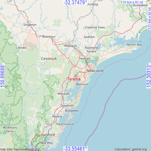
Teralba GPS coordinates[2]
32° 58' 0.012" South, 151° 36' 0" East
| Map corner | latitude | longitude |
|---|---|---|
| Upper-left | -32.37479°, | 150.89688° |
| Center: | -32.96667°, | 151.6° |
| Lower-right: | -33.55461°, | 152.30313° |
| Map W x H: | 131.2×131.2 km | = 81.5×81.5mi |
| max Lat: | -10.58257° ⇑42.2% North |
| Teralba: | -32.96667° |
| min Lat: | ⇓57.8% South -43.31423° |
| min Long | Teralba | max Long |
| 113.53327° | 151.6° | 153.61246° |
| W 78.9%⇐ | ⇒21.1% E |
Elevation
Elevation of Teralba is 18 m = 59 ft, and this is 104 m = 341 ft below average elevation for this country.
| Max E: |
1715 m = 5627 ft | 76.1% |
| Avg. | 122 m = 400 ft | |
| Teralba | 18 m = 59 ft | |
Min E: |
-2 m = -7 ft | 23.9% |
See also: Australia elevation on elevation.city.
Geographical zone
Teralba is located in South temperate zone (between Tropic of Capricorn and the Antarctic Circle). Distance of this Southern Tropic circle is 1059.6 km =658.4 mi to North.| Distance of | km | miles | from Teralba |
|---|---|---|---|
| Equator | 3665.6 | 2277.7 | to North |
| Tropic Capricorn | 1059.6 | 658.4 | to North |
| Antarctic Circle | 3735.6 | 2321.2 | to South |
| South Pole | 6341.5 | 3940.4 | to South |


Nearby cities:
15 places around Teralba: (largest is in red/bold)
• Argenton
4.5 km =2.8 mi,  39°
39°
• Barnsley
4 km =2.5 mi,  337°
337°
• Blackalls Park
4 km =2.5 mi,  207°
207°
• Bolton Point
4 km =2.5 mi,  166°
166°
• Boolaroo
3.4 km =2.1 mi,  49°
49°
• Booragul
1.3 km =0.8 mi,  134°
134°
• Edgeworth
4.9 km =3 mi,  18°
18°
• Eleebana
4.2 km =2.6 mi, 126°
• Fassifern
2.4 km =1.5 mi,  220°
220°
• Fennell Bay
2.8 km =1.7 mi,  179°
179°
• Lakelands
4.7 km =2.9 mi,  83°
83°
• Macquarie Hills
4.5 km =2.8 mi,  67°
67°
• Marmong Point
2.3 km =1.4 mi, 132°
• Speers Point
2.5 km =1.6 mi, 82°
• Woodrising
2.2 km =1.4 mi,  164°
164°
Sources, notices
• [Note1] Compared only with cities in Australia existing in our database
• [Src1] Map data: © OpenStreetMap contributors (CC-BY-SA)
• [Src2] Other city data from geonames.org with taken over terms of usage.
• [Src3] Geographical zone / Annual Mean Temperature by Robert A. Rohde @ Wikipedia
