Booragul geodata
Booragul (New South Wales) is a section of populated place; located in Australia in Australia/Sydney (GMT+11) time zone. With population of 1,259 people, there are 3513 cities with bigger population in this country. Compared to other cities in Australia, 57.7% of cities are located further ↓South; 79.1% of cities are located further ←West and 73.6% of cities have higher elevation than Booragul. Note1


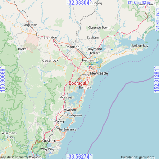
Booragul GPS coordinates[2]
32° 58' 29.496" South, 151° 36' 35.208" East
| Map corner | latitude | longitude |
|---|---|---|
| Upper-left | -32.38304°, | 150.90666° |
| Center: | -32.97486°, | 151.60978° |
| Lower-right: | -33.56274°, | 152.31291° |
| Map W x H: | 131.2×131.2 km | = 81.5×81.5mi |
| max Lat: | -10.58257° ⇑42.3% North |
| Booragul: | -32.97486° |
| min Lat: | ⇓57.7% South -43.31423° |
| min Long | Booragul | max Long |
| 113.53327° | 151.60978° | 153.61246° |
| W 79.1%⇐ | ⇒20.9% E |
Elevation
Elevation of Booragul is 20 m = 66 ft, and this is 102 m = 335 ft below average elevation for this country.
| Max E: |
1715 m = 5627 ft | 73.6% |
| Avg. | 122 m = 400 ft | |
| Booragul | 20 m = 66 ft | |
Min E: |
-2 m = -7 ft | 26.4% |
See also: Australia elevation on elevation.city.
Geographical zone
Booragul is located in South temperate zone (between Tropic of Capricorn and the Antarctic Circle). Distance of this Southern Tropic circle is 1060.5 km =659 mi to North.| Distance of | km | miles | from Booragul |
|---|---|---|---|
| Equator | 3666.5 | 2278.3 | to North |
| Tropic Capricorn | 1060.5 | 659 | to North |
| Antarctic Circle | 3734.7 | 2320.6 | to South |
| South Pole | 6340.6 | 3939.9 | to South |


Nearby cities:
15 places around Booragul: (largest is in red/bold)
• Argenton
4.8 km =3 mi,  23°
23°
• Blackalls Park
3.8 km =2.4 mi,  225°
225°
• Bolton Point
3 km =1.9 mi,  179°
179°
• Boolaroo
3.5 km =2.2 mi,  28°
28°
• Eleebana
3 km =1.9 mi,  123°
123°
• Fassifern
2.6 km =1.6 mi,  249°
249°
• Fennell Bay
2.1 km =1.3 mi,  205°
205°
• Lakelands
4 km =2.5 mi,  68°
68°
• Macquarie Hills
4.2 km =2.6 mi,  50°
50°
• Marmong Point
1 km =0.6 mi,  128°
128°
• Speers Point
2 km =1.2 mi, 51°
• Teralba
1.3 km =0.8 mi,  314°
314°
• Toronto
4.6 km =2.9 mi,  199°
199°
• Warners Bay
4 km =2.5 mi,  86°
86°
• Woodrising
1.3 km =0.8 mi,  193°
193°
Sources, notices
• [Note1] Compared only with cities in Australia existing in our database
• [Src1] Map data: © OpenStreetMap contributors (CC-BY-SA)
• [Src2] Other city data from geonames.org with taken over terms of usage.
• [Src3] Geographical zone / Annual Mean Temperature by Robert A. Rohde @ Wikipedia
