Shortland geodata
Shortland (New South Wales) is a section of populated place; located in Australia in Australia/Sydney (GMT+11) time zone. With population of 3,922 people, there are 1821 cities with bigger population in this country. Compared to other cities in Australia, 59.2% of cities are located further ↓South; 80.4% of cities are located further ←West and 70.9% of cities have higher elevation than Shortland. Note1


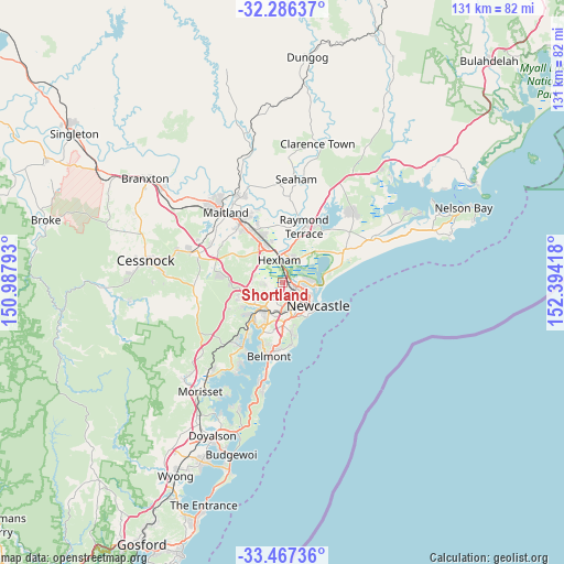
Shortland GPS coordinates[2]
32° 52' 43.788" South, 151° 41' 27.78" East
| Map corner | latitude | longitude |
|---|---|---|
| Upper-left | -32.28637°, | 150.98793° |
| Center: | -32.87883°, | 151.69105° |
| Lower-right: | -33.46736°, | 152.39418° |
| Map W x H: | 131.3×131.3 km | = 81.6×81.6mi |
| max Lat: | -10.58257° ⇑40.8% North |
| Shortland: | -32.87883° |
| min Lat: | ⇓59.2% South -43.31423° |
| min Long | Shortland | max Long |
| 113.53327° | 151.69105° | 153.61246° |
| W 80.4%⇐ | ⇒19.6% E |
Elevation
Elevation of Shortland is 22 m = 72 ft, and this is 100 m = 328 ft below average elevation for this country.
| Max E: |
1715 m = 5627 ft | 70.9% |
| Avg. | 122 m = 400 ft | |
| Shortland | 22 m = 72 ft | |
Min E: |
-2 m = -7 ft | 29.1% |
See also: Australia elevation on elevation.city.
Geographical zone
Shortland is located in South temperate zone (between Tropic of Capricorn and the Antarctic Circle). Distance of this Southern Tropic circle is 1049.9 km =652.4 mi to North.| Distance of | km | miles | from Shortland |
|---|---|---|---|
| Equator | 3655.8 | 2271.6 | to North |
| Tropic Capricorn | 1049.9 | 652.4 | to North |
| Antarctic Circle | 3745.4 | 2327.3 | to South |
| South Pole | 6351.3 | 3946.5 | to South |


Nearby cities:
15 places around Shortland: (largest is in red/bold)
• Birmingham Gardens
1.7 km =1.1 mi,  183°
183°
• Callaghan
2 km =1.2 mi,  137°
137°
• Elermore Vale
4.4 km =2.7 mi,  197°
197°
• Fletcher
4.8 km =3 mi,  278°
278°
• Georgetown
5 km =3.1 mi,  130°
130°
• Jesmond
2.7 km =1.7 mi, 180°
• Lambton
4.3 km =2.7 mi,  168°
168°
• Maryland
2.8 km =1.7 mi,  269°
269°
• Mayfield
4.7 km =2.9 mi,  116°
116°
• Mayfield West
3.7 km =2.3 mi,  113°
113°
• North Lambton
3.3 km =2.1 mi,  155°
155°
• Wallsend
3.5 km =2.2 mi,  224°
224°
• Warabrook
2.5 km =1.6 mi, 116°
• Waratah
4.5 km =2.8 mi, 133°
• Waratah West
3 km =1.9 mi, 140°
Sources, notices
• [Note1] Compared only with cities in Australia existing in our database
• [Src1] Map data: © OpenStreetMap contributors (CC-BY-SA)
• [Src2] Other city data from geonames.org with taken over terms of usage.
• [Src3] Geographical zone / Annual Mean Temperature by Robert A. Rohde @ Wikipedia
