Tarragindi geodata
Tarragindi (Queensland) is a section of populated place; located in Australia in Australia/Brisbane (GMT+10) time zone. With population of 10,572 people, there are 531 cities with bigger population in this country. Compared to other cities in Australia, 81.4% of cities are located further ↓South; 92.9% of cities are located further ←West and 52.8% of cities have lower elevation than Tarragindi. Note1


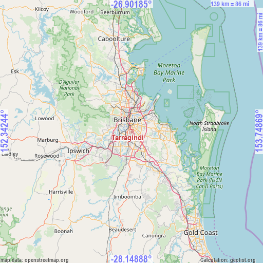
Tarragindi GPS coordinates[2]
27° 31' 37.668" South, 153° 2' 44.016" East
| Map corner | latitude | longitude |
|---|---|---|
| Upper-left | -26.90185°, | 152.34244° |
| Center: | -27.52713°, | 153.04556° |
| Lower-right: | -28.14888°, | 153.74869° |
| Map W x H: | 138.7×138.7 km | = 86.2×86.2mi |
| max Lat: | -10.58257° ⇑18.6% North |
| Tarragindi: | -27.52713° |
| min Lat: | ⇓81.4% South -43.31423° |
| min Long | Tarragindi | max Long |
| 113.53327° | 153.04556° | 153.61246° |
| W 92.9%⇐ | ⇒7.1% E |
Elevation
Elevation of Tarragindi is 49 m = 161 ft, and this is 73 m = 240 ft below average elevation for this country.
| Max E: |
1715 m = 5627 ft | 47.2% |
| Avg. | 122 m = 400 ft | |
| Tarragindi | 49 m = 161 ft | |
Min E: |
-2 m = -7 ft | 52.8% |
See also: Australia elevation on elevation.city.
Geographical zone
Tarragindi is located in South temperate zone (between Tropic of Capricorn and the Antarctic Circle). Distance of this Southern Tropic circle is 454.8 km =282.6 mi to North.| Distance of | km | miles | from Tarragindi |
|---|---|---|---|
| Equator | 3060.7 | 1901.8 | to North |
| Tropic Capricorn | 454.8 | 282.6 | to North |
| Antarctic Circle | 4340.4 | 2697 | to South |
| South Pole | 6946.3 | 4316.2 | to South |


Nearby cities:
15 places around Tarragindi: (largest is in red/bold)
• Annerley
2.1 km =1.3 mi,  322°
322°
• Coopers Plains
4.2 km =2.6 mi,  186°
186°
• Coorparoo
4 km =2.5 mi,  18°
18°
• Dutton Park
3.8 km =2.4 mi,  332°
332°
• Fairfield
3.1 km =1.9 mi, 318°
• Greenslopes
2.1 km =1.3 mi,  10°
10°
• Holland Park
2.4 km =1.5 mi,  62°
62°
• Holland Park West
1.5 km =0.9 mi,  86°
86°
• Moorooka
2.2 km =1.4 mi,  248°
248°
• Mount Gravatt
3.8 km =2.4 mi,  100°
100°
• Mount Gravatt East
3.9 km =2.4 mi,  112°
112°
• Nathan
3.9 km =2.4 mi,  154°
154°
• Salisbury
3 km =1.9 mi,  205°
205°
• Yeerongpilly
3.6 km =2.2 mi,  263°
263°
• Yeronga
3.1 km =1.9 mi,  293°
293°
Sources, notices
• [Note1] Compared only with cities in Australia existing in our database
• [Src1] Map data: © OpenStreetMap contributors (CC-BY-SA)
• [Src2] Other city data from geonames.org with taken over terms of usage.
• [Src3] Geographical zone / Annual Mean Temperature by Robert A. Rohde @ Wikipedia
