Salisbury geodata
Salisbury (Queensland) is a section of populated place; located in Australia in Australia/Brisbane (GMT+10) time zone. With population of 6,203 people, there are 1150 cities with bigger population in this country. Compared to other cities in Australia, 80.7% of cities are located further ↓South; 92.5% of cities are located further ←West and 59.2% of cities have higher elevation than Salisbury. Note1


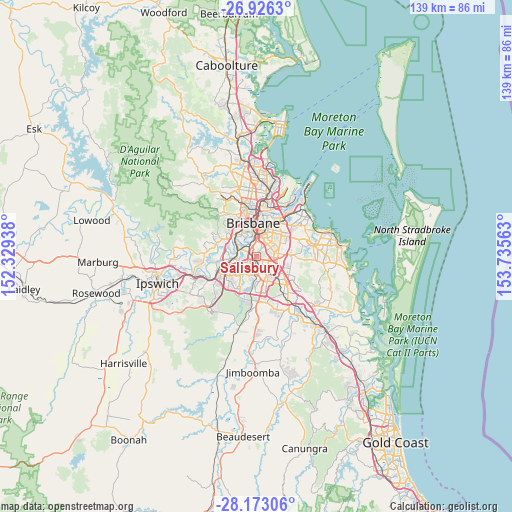
Salisbury GPS coordinates[2]
27° 33' 5.22" South, 153° 1' 57" East
| Map corner | latitude | longitude |
|---|---|---|
| Upper-left | -26.9263°, | 152.32938° |
| Center: | -27.55145°, | 153.0325° |
| Lower-right: | -28.17306°, | 153.73563° |
| Map W x H: | 138.6×138.6 km | = 86.1×86.1mi |
| max Lat: | -10.58257° ⇑19.3% North |
| Salisbury: | -27.55145° |
| min Lat: | ⇓80.7% South -43.31423° |
| min Long | Salisbury | max Long |
| 113.53327° | 153.0325° | 153.61246° |
| W 92.5%⇐ | ⇒7.5% E |
Elevation
Elevation of Salisbury is 33 m = 108 ft, and this is 89 m = 292 ft below average elevation for this country.
| Max E: |
1715 m = 5627 ft | 59.2% |
| Avg. | 122 m = 400 ft | |
| Salisbury | 33 m = 108 ft | |
Min E: |
-2 m = -7 ft | 40.8% |
See also: Australia elevation on elevation.city.
Geographical zone
Salisbury is located in South temperate zone (between Tropic of Capricorn and the Antarctic Circle). Distance of this Southern Tropic circle is 457.5 km =284.3 mi to North.| Distance of | km | miles | from Salisbury |
|---|---|---|---|
| Equator | 3063.4 | 1903.5 | to North |
| Tropic Capricorn | 457.5 | 284.3 | to North |
| Antarctic Circle | 4337.7 | 2695.3 | to South |
| South Pole | 6943.6 | 4314.6 | to South |


Nearby cities:
15 places around Salisbury: (largest is in red/bold)
• Acacia Ridge
3.5 km =2.2 mi,  178°
178°
• Annerley
4.4 km =2.7 mi,  359°
359°
• Archerfield
2.5 km =1.6 mi,  225°
225°
• Coopers Plains
1.7 km =1.1 mi,  151°
151°
• Holland Park West
3.9 km =2.4 mi,  44°
44°
• Macgregor
3.7 km =2.3 mi,  114°
114°
• Moorooka
2.1 km =1.3 mi,  337°
337°
• Nathan
3.1 km =1.9 mi, 105°
• Robertson
2.9 km =1.8 mi,  123°
123°
• Rocklea
3.1 km =1.9 mi,  295°
295°
• Sunnybank
4.2 km =2.6 mi,  138°
138°
• Tarragindi
3 km =1.9 mi,  25°
25°
• Tennyson
4.3 km =2.7 mi,  310°
310°
• Yeerongpilly
3.2 km =2 mi, 314°
• Yeronga
4.3 km =2.7 mi, 338°
Sources, notices
• [Note1] Compared only with cities in Australia existing in our database
• [Src1] Map data: © OpenStreetMap contributors (CC-BY-SA)
• [Src2] Other city data from geonames.org with taken over terms of usage.
• [Src3] Geographical zone / Annual Mean Temperature by Robert A. Rohde @ Wikipedia
