Nathan geodata
Nathan (Queensland) is a section of populated place; located in Australia in Australia/Brisbane (GMT+10) time zone. With population of 1,179 people, there are 3608 cities with bigger population in this country. Compared to other cities in Australia, 80.5% of cities are located further ↓South; 93.6% of cities are located further ←West and 67.6% of cities have lower elevation than Nathan. Note1


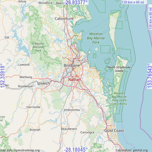
Nathan GPS coordinates[2]
27° 33' 31.968" South, 153° 3' 44.28" East
| Map corner | latitude | longitude |
|---|---|---|
| Upper-left | -26.93377°, | 152.35918° |
| Center: | -27.55888°, | 153.0623° |
| Lower-right: | -28.18045°, | 153.76543° |
| Map W x H: | 138.6×138.6 km | = 86.1×86.1mi |
| max Lat: | -10.58257° ⇑19.5% North |
| Nathan: | -27.55888° |
| min Lat: | ⇓80.5% South -43.31423° |
| min Long | Nathan | max Long |
| 113.53327° | 153.0623° | 153.61246° |
| W 93.6%⇐ | ⇒6.4% E |
Elevation
Elevation of Nathan is 91 m = 299 ft, and this is 31 m = 102 ft below average elevation for this country.
| Max E: |
1715 m = 5627 ft | 32.4% |
| Avg. | 122 m = 400 ft | |
| Nathan | 91 m = 299 ft | |
Min E: |
-2 m = -7 ft | 67.6% |
See also: Australia elevation on elevation.city.
Geographical zone
Nathan is located in South temperate zone (between Tropic of Capricorn and the Antarctic Circle). Distance of this Southern Tropic circle is 458.3 km =284.8 mi to North.| Distance of | km | miles | from Nathan |
|---|---|---|---|
| Equator | 3064.3 | 1904.1 | to North |
| Tropic Capricorn | 458.3 | 284.8 | to North |
| Antarctic Circle | 4336.9 | 2694.8 | to South |
| South Pole | 6942.8 | 4314.1 | to South |


Nearby cities:
15 places around Nathan: (largest is in red/bold)
• Acacia Ridge
3.9 km =2.4 mi,  226°
226°
• Coopers Plains
2.2 km =1.4 mi,  253°
253°
• Eight Mile Plains
4.6 km =2.9 mi,  126°
126°
• Holland Park West
3.6 km =2.2 mi,  357°
357°
• Macgregor
0.8 km =0.5 mi,  148°
148°
• Mansfield
4.2 km =2.6 mi,  58°
58°
• Mount Gravatt
3.5 km =2.2 mi,  36°
36°
• Mount Gravatt East
2.8 km =1.7 mi, 43°
• Robertson
0.9 km =0.6 mi,  212°
212°
• Runcorn
4.5 km =2.8 mi,  161°
161°
• Salisbury
3.1 km =1.9 mi,  285°
285°
• Sunnybank
2.4 km =1.5 mi,  183°
183°
• Tarragindi
3.9 km =2.4 mi,  334°
334°
• Upper Mount Gravatt
2.2 km =1.4 mi,  96°
96°
• Wishart
3.9 km =2.4 mi,  82°
82°
Sources, notices
• [Note1] Compared only with cities in Australia existing in our database
• [Src1] Map data: © OpenStreetMap contributors (CC-BY-SA)
• [Src2] Other city data from geonames.org with taken over terms of usage.
• [Src3] Geographical zone / Annual Mean Temperature by Robert A. Rohde @ Wikipedia
