Swan Reach geodata
Swan Reach (Victoria) is a populated place; located in Australia in Australia/Melbourne (GMT+11) time zone. With population of 710 people, there are 4308 cities with bigger population in this country. Compared to other cities in Australia, 88.8% of cities are located further ↑North; 50.7% of cities are located further ←West and 77.5% of cities have higher elevation than Swan Reach. Note1


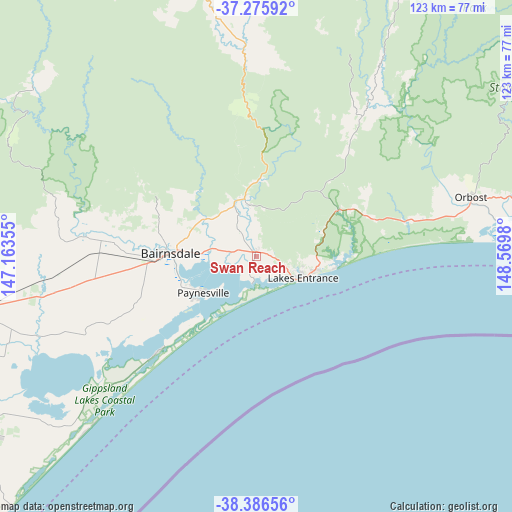
Swan Reach GPS coordinates[2]
37° 49' 59.988" South, 147° 52' 0.012" East
| Map corner | latitude | longitude |
|---|---|---|
| Upper-left | -37.27592°, | 147.16355° |
| Center: | -37.83333°, | 147.86667° |
| Lower-right: | -38.38656°, | 148.5698° |
| Map W x H: | 123.5×123.5 km | = 76.7×76.7mi |
| max Lat: | -10.58257° ⇑88.8% North |
| Swan Reach: | -37.83333° |
| min Lat: | ⇓11.2% South -43.31423° |
| min Long | Swan Reach | max Long |
| 113.53327° | 147.86667° | 153.61246° |
| W 50.7%⇐ | ⇒49.3% E |
Elevation
Elevation of Swan Reach is 17 m = 56 ft, and this is 105 m = 344 ft below average elevation for this country.
| Max E: |
1715 m = 5627 ft | 77.5% |
| Avg. | 122 m = 400 ft | |
| Swan Reach | 17 m = 56 ft | |
Min E: |
-2 m = -7 ft | 22.5% |
See also: Australia elevation on elevation.city.
Geographical zone
Swan Reach is located in South temperate zone (between Tropic of Capricorn and the Antarctic Circle). Distance of this Southern Tropic circle is 1600.8 km =994.7 mi to North.| Distance of | km | miles | from Swan Reach |
|---|---|---|---|
| Equator | 4206.7 | 2613.9 | to North |
| Tropic Capricorn | 1600.8 | 994.7 | to North |
| Antarctic Circle | 3194.5 | 1985 | to South |
| South Pole | 5800.4 | 3604.2 | to South |


Nearby cities:
15 places around Swan Reach: (largest is in red/bold)
• Bairnsdale
22.5 km =14 mi,  272°
272°
• Bruthen
14.4 km =8.9 mi,  347°
347°
• Eagle Point
17.7 km =11 mi,  245°
245°
• East Bairnsdale
18.5 km =11.5 mi, 269°
• Kalimna
9.7 km =6 mi,  114°
114°
• Lake Tyers Beach
18.1 km =11.2 mi,  100°
100°
• Lakes Entrance
12.4 km =7.7 mi, 107°
• Loch Sport
33.3 km =20.7 mi,  226°
226°
• Lucknow
19.1 km =11.9 mi,  275°
275°
• Metung
6.6 km =4.1 mi,  190°
190°
• Newlands Arm
18.7 km =11.6 mi,  235°
235°
• Nicholson
11.9 km =7.4 mi, 278°
• Paynesville
16 km =9.9 mi, 233°
• Sarsfield
16.1 km =10 mi,  305°
305°
• Wy Yung
25.2 km =15.7 mi, 278°
Sources, notices
• [Note1] Compared only with cities in Australia existing in our database
• [Src1] Map data: © OpenStreetMap contributors (CC-BY-SA)
• [Src2] Other city data from geonames.org with taken over terms of usage.
• [Src3] Geographical zone / Annual Mean Temperature by Robert A. Rohde @ Wikipedia
