Nicholson geodata
Nicholson (Victoria) is a populated place; located in Australia in Australia/Melbourne (GMT+11) time zone. With population of 1,045 people, there are 3760 cities with bigger population in this country. Compared to other cities in Australia, 88.2% of cities are located further ↑North; 50.6% of cities are located further ←West and 79% of cities have higher elevation than Nicholson. Note1


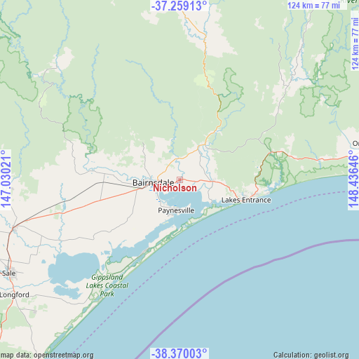
Nicholson GPS coordinates[2]
37° 49' 0.012" South, 147° 43' 59.988" East
| Map corner | latitude | longitude |
|---|---|---|
| Upper-left | -37.25913°, | 147.03021° |
| Center: | -37.81667°, | 147.73333° |
| Lower-right: | -38.37003°, | 148.43646° |
| Map W x H: | 123.5×123.5 km | = 76.7×76.7mi |
| max Lat: | -10.58257° ⇑88.2% North |
| Nicholson: | -37.81667° |
| min Lat: | ⇓11.8% South -43.31423° |
| min Long | Nicholson | max Long |
| 113.53327° | 147.73333° | 153.61246° |
| W 50.6%⇐ | ⇒49.4% E |
Elevation
Elevation of Nicholson is 16 m = 52 ft, and this is 106 m = 348 ft below average elevation for this country.
| Max E: |
1715 m = 5627 ft | 79% |
| Avg. | 122 m = 400 ft | |
| Nicholson | 16 m = 52 ft | |
Min E: |
-2 m = -7 ft | 21% |
See also: Australia elevation on elevation.city.
Geographical zone
Nicholson is located in South temperate zone (between Tropic of Capricorn and the Antarctic Circle). Distance of this Southern Tropic circle is 1598.9 km =993.5 mi to North.| Distance of | km | miles | from Nicholson |
|---|---|---|---|
| Equator | 4204.8 | 2612.7 | to North |
| Tropic Capricorn | 1598.9 | 993.5 | to North |
| Antarctic Circle | 3196.4 | 1986.2 | to South |
| South Pole | 5802.2 | 3605.3 | to South |


Nearby cities:
15 places around Nicholson: (largest is in red/bold)
• Bairnsdale
10.8 km =6.7 mi,  266°
266°
• Bruthen
14.9 km =9.3 mi,  35°
35°
• Eagle Point
10.3 km =6.4 mi,  205°
205°
• East Bairnsdale
7.1 km =4.4 mi,  254°
254°
• Kalimna
21.3 km =13.2 mi,  106°
106°
• Lake Tyers Beach
29.9 km =18.6 mi,  99°
99°
• Lakes Entrance
24.2 km =15 mi, 103°
• Loch Sport
27.8 km =17.3 mi, 206°
• Lucknow
7.3 km =4.5 mi, 270°
• Metung
13.4 km =8.3 mi,  128°
128°
• Newlands Arm
13 km =8.1 mi,  196°
196°
• Paynesville
11.4 km =7.1 mi,  186°
186°
• Sarsfield
7.6 km =4.7 mi,  348°
348°
• Swan Reach
11.9 km =7.4 mi, 98°
• Wy Yung
13.3 km =8.3 mi,  278°
278°
Sources, notices
• [Note1] Compared only with cities in Australia existing in our database
• [Src1] Map data: © OpenStreetMap contributors (CC-BY-SA)
• [Src2] Other city data from geonames.org with taken over terms of usage.
• [Src3] Geographical zone / Annual Mean Temperature by Robert A. Rohde @ Wikipedia
