Sulphur Creek geodata
Sulphur Creek (Tasmania) is a populated place; located in Australia in Australia/Hobart (GMT+11) time zone. With population of 609 people, there are 4545 cities with bigger population in this country. Compared to other cities in Australia, 96.6% of cities are located further ↑North; 57% of cities are located further →East and 86.8% of cities have higher elevation than Sulphur Creek. Note1


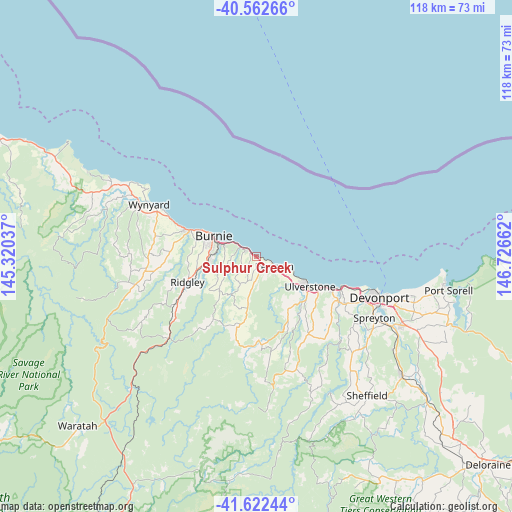
Sulphur Creek GPS coordinates[2]
41° 5' 40.884" South, 146° 1' 24.564" East
| Map corner | latitude | longitude |
|---|---|---|
| Upper-left | -40.56266°, | 145.32037° |
| Center: | -41.09469°, | 146.02349° |
| Lower-right: | -41.62244°, | 146.72662° |
| Map W x H: | 117.8×117.8 km | = 73.2×73.2mi |
| max Lat: | -10.58257° ⇑96.6% North |
| Sulphur Creek: | -41.09469° |
| min Lat: | ⇓3.4% South -43.31423° |
| min Long | Sulphur Creek | max Long |
| 113.53327° | 146.02349° | 153.61246° |
| W 43%⇐ | ⇒57% E |
Elevation
Elevation of Sulphur Creek is 11 m = 36 ft, and this is 111 m = 364 ft below average elevation for this country.
| Max E: |
1715 m = 5627 ft | 86.8% |
| Avg. | 122 m = 400 ft | |
| Sulphur Creek | 11 m = 36 ft | |
Min E: |
-2 m = -7 ft | 13.2% |
See also: Australia elevation on elevation.city.
Geographical zone
Sulphur Creek is located in South temperate zone (between Tropic of Capricorn and the Antarctic Circle). Distance of this Southern Tropic circle is 1963.4 km =1220 mi to North.| Distance of | km | miles | from Sulphur Creek |
|---|---|---|---|
| Equator | 4569.3 | 2839.2 | to North |
| Tropic Capricorn | 1963.4 | 1220 | to North |
| Antarctic Circle | 2831.9 | 1759.7 | to South |
| South Pole | 5437.8 | 3378.9 | to South |


Nearby cities:
15 places around Sulphur Creek: (largest is in red/bold)
• Brooklyn
10.1 km =6.3 mi,  284°
284°
• Burnie
10.9 km =6.8 mi,  293°
293°
• Burnie city centre
10.8 km =6.7 mi, 294°
• Cooee
13.8 km =8.6 mi, 293°
• Gawler
15.7 km =9.8 mi,  134°
134°
• Havenview
9.4 km =5.8 mi, 277°
• Hillcrest
11.4 km =7.1 mi, 287°
• Montello
11.4 km =7.1 mi, 291°
• Park Grove
12.7 km =7.9 mi, 290°
• Penguin
5.2 km =3.2 mi, 126°
• Romaine
10.9 km =6.8 mi,  267°
267°
• Shorewell Park
12.6 km =7.8 mi, 282°
• Ulverstone
15.2 km =9.4 mi,  118°
118°
• Upper Burnie
10.7 km =6.6 mi, 284°
• West Ulverstone
10.4 km =6.5 mi, 124°
Sources, notices
• [Note1] Compared only with cities in Australia existing in our database
• [Src1] Map data: © OpenStreetMap contributors (CC-BY-SA)
• [Src2] Other city data from geonames.org with taken over terms of usage.
• [Src3] Geographical zone / Annual Mean Temperature by Robert A. Rohde @ Wikipedia
