Strathpine geodata
Strathpine (Queensland) is a section of populated place; located in Australia in Australia/Brisbane (GMT+10) time zone. With population of 9,352 people, there are 660 cities with bigger population in this country. Compared to other cities in Australia, 84.6% of cities are located further ↓South; 90.8% of cities are located further ←West and 91.8% of cities have higher elevation than Strathpine. Note1


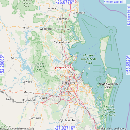
Strathpine GPS coordinates[2]
27° 18' 14.904" South, 152° 59' 23.172" East
| Map corner | latitude | longitude |
|---|---|---|
| Upper-left | -26.6776°, | 152.28665° |
| Center: | -27.30414°, | 152.98977° |
| Lower-right: | -27.92716°, | 153.6929° |
| Map W x H: | 138.9×138.9 km | = 86.3×86.3mi |
| max Lat: | -10.58257° ⇑15.4% North |
| Strathpine: | -27.30414° |
| min Lat: | ⇓84.6% South -43.31423° |
| min Long | Strathpine | max Long |
| 113.53327° | 152.98977° | 153.61246° |
| W 90.8%⇐ | ⇒9.2% E |
Elevation
Elevation of Strathpine is 8 m = 26 ft, and this is 114 m = 374 ft below average elevation for this country.
| Max E: |
1715 m = 5627 ft | 91.8% |
| Avg. | 122 m = 400 ft | |
| Strathpine | 8 m = 26 ft | |
Min E: |
-2 m = -7 ft | 8.2% |
See also: Australia elevation on elevation.city.
Geographical zone
Strathpine is located in South temperate zone (between Tropic of Capricorn and the Antarctic Circle). Distance of this Southern Tropic circle is 430 km =267.2 mi to North.| Distance of | km | miles | from Strathpine |
|---|---|---|---|
| Equator | 3035.9 | 1886.4 | to North |
| Tropic Capricorn | 430 | 267.2 | to North |
| Antarctic Circle | 4365.2 | 2712.4 | to South |
| South Pole | 6971.1 | 4331.6 | to South |


Nearby cities:
15 places around Strathpine: (largest is in red/bold)
• Albany Creek
5.9 km =3.7 mi,  200°
200°
• Bald Hills
2.6 km =1.6 mi,  135°
135°
• Bracken Ridge
4.3 km =2.7 mi,  109°
109°
• Bray Park
2.5 km =1.6 mi,  300°
300°
• Brendale
2 km =1.2 mi, 196°
• Bridgeman Downs
5.7 km =3.5 mi,  175°
175°
• Carseldine
5.8 km =3.6 mi,  145°
145°
• Eatons Hill
4.9 km =3 mi,  217°
217°
• Fitzgibbon
5.6 km =3.5 mi, 135°
• Joyner
5.4 km =3.4 mi, 304°
• Kallangur
5.8 km =3.6 mi,  2°
2°
• Lawnton
2.4 km =1.5 mi,  344°
344°
• Murrumba Downs
4.6 km =2.9 mi,  26°
26°
• Petrie
4.2 km =2.6 mi,  351°
351°
• Warner
4 km =2.5 mi,  257°
257°
Sources, notices
• [Note1] Compared only with cities in Australia existing in our database
• [Src1] Map data: © OpenStreetMap contributors (CC-BY-SA)
• [Src2] Other city data from geonames.org with taken over terms of usage.
• [Src3] Geographical zone / Annual Mean Temperature by Robert A. Rohde @ Wikipedia
