Warner geodata
Warner (Queensland) is a section of populated place; located in Australia in Australia/Brisbane (GMT+10) time zone. With population of 11,209 people, there are 483 cities with bigger population in this country. Compared to other cities in Australia, 84.5% of cities are located further ↓South; 89.6% of cities are located further ←West and 58.5% of cities have lower elevation than Warner. Note1


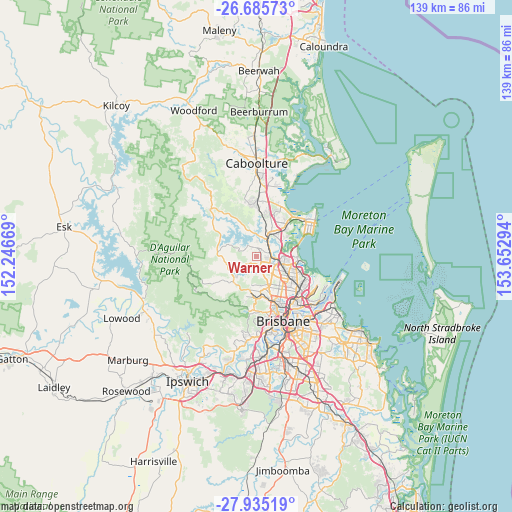
Warner GPS coordinates[2]
27° 18' 43.992" South, 152° 56' 59.316" East
| Map corner | latitude | longitude |
|---|---|---|
| Upper-left | -26.68573°, | 152.24669° |
| Center: | -27.31222°, | 152.94981° |
| Lower-right: | -27.93519°, | 153.65294° |
| Map W x H: | 138.9×138.9 km | = 86.3×86.3mi |
| max Lat: | -10.58257° ⇑15.5% North |
| Warner: | -27.31222° |
| min Lat: | ⇓84.5% South -43.31423° |
| min Long | Warner | max Long |
| 113.53327° | 152.94981° | 153.61246° |
| W 89.6%⇐ | ⇒10.4% E |
Elevation
Elevation of Warner is 60 m = 197 ft, and this is 62 m = 203 ft below average elevation for this country.
| Max E: |
1715 m = 5627 ft | 41.5% |
| Avg. | 122 m = 400 ft | |
| Warner | 60 m = 197 ft | |
Min E: |
-2 m = -7 ft | 58.5% |
See also: Australia elevation on elevation.city.
Geographical zone
Warner is located in South temperate zone (between Tropic of Capricorn and the Antarctic Circle). Distance of this Southern Tropic circle is 430.9 km =267.7 mi to North.| Distance of | km | miles | from Warner |
|---|---|---|---|
| Equator | 3036.8 | 1887 | to North |
| Tropic Capricorn | 430.9 | 267.7 | to North |
| Antarctic Circle | 4364.3 | 2711.8 | to South |
| South Pole | 6970.2 | 4331.1 | to South |


Nearby cities:
15 places around Warner: (largest is in red/bold)
• Albany Creek
5 km =3.1 mi,  158°
158°
• Bald Hills
5.9 km =3.7 mi,  99°
99°
• Bray Park
2.8 km =1.7 mi,  39°
39°
• Brendale
3.5 km =2.2 mi,  106°
106°
• Bridgeman Downs
6.5 km =4 mi,  137°
137°
• Bunya
6.4 km =4 mi,  185°
185°
• Cashmere
4.6 km =2.9 mi,  290°
290°
• Clear Mountain
6.6 km =4.1 mi,  276°
276°
• Draper
6.2 km =3.9 mi,  223°
223°
• Eatons Hill
3.2 km =2 mi, 161°
• Joyner
4 km =2.5 mi,  352°
352°
• Lawnton
4.6 km =2.9 mi,  45°
45°
• Petrie
6.1 km =3.8 mi,  33°
33°
• Strathpine
4 km =2.5 mi,  77°
77°
• Whiteside
7.2 km =4.5 mi,  328°
328°
Sources, notices
• [Note1] Compared only with cities in Australia existing in our database
• [Src1] Map data: © OpenStreetMap contributors (CC-BY-SA)
• [Src2] Other city data from geonames.org with taken over terms of usage.
• [Src3] Geographical zone / Annual Mean Temperature by Robert A. Rohde @ Wikipedia
