Joyner geodata
Joyner (Queensland) is a section of populated place; located in Australia in Australia/Brisbane (GMT+10) time zone. With population of 2,784 people, there are 2386 cities with bigger population in this country. Compared to other cities in Australia, 84.7% of cities are located further ↓South; 89.4% of cities are located further ←West and 60% of cities have higher elevation than Joyner. Note1


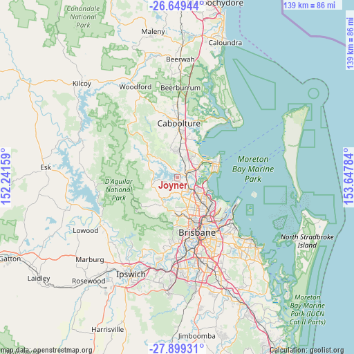
Joyner GPS coordinates[2]
27° 16' 34.068" South, 152° 56' 40.956" East
| Map corner | latitude | longitude |
|---|---|---|
| Upper-left | -26.64944°, | 152.24159° |
| Center: | -27.27613°, | 152.94471° |
| Lower-right: | -27.89931°, | 153.64784° |
| Map W x H: | 139×139 km | = 86.4×86.4mi |
| max Lat: | -10.58257° ⇑15.3% North |
| Joyner: | -27.27613° |
| min Lat: | ⇓84.7% South -43.31423° |
| min Long | Joyner | max Long |
| 113.53327° | 152.94471° | 153.61246° |
| W 89.4%⇐ | ⇒10.6% E |
Elevation
Elevation of Joyner is 32 m = 105 ft, and this is 90 m = 295 ft below average elevation for this country.
| Max E: |
1715 m = 5627 ft | 60% |
| Avg. | 122 m = 400 ft | |
| Joyner | 32 m = 105 ft | |
Min E: |
-2 m = -7 ft | 40% |
See also: Australia elevation on elevation.city.
Geographical zone
Joyner is located in South temperate zone (between Tropic of Capricorn and the Antarctic Circle). Distance of this Southern Tropic circle is 426.9 km =265.3 mi to North.| Distance of | km | miles | from Joyner |
|---|---|---|---|
| Equator | 3032.8 | 1884.5 | to North |
| Tropic Capricorn | 426.9 | 265.3 | to North |
| Antarctic Circle | 4368.4 | 2714.4 | to South |
| South Pole | 6974.2 | 4333.6 | to South |


Nearby cities:
15 places around Joyner: (largest is in red/bold)
• Bald Hills
8.1 km =5 mi,  128°
128°
• Bray Park
2.9 km =1.8 mi, 128°
• Brendale
6.3 km =3.9 mi,  142°
142°
• Cashmere
4.5 km =2.8 mi,  237°
237°
• Clear Mountain
6.9 km =4.3 mi, 242°
• Dakabin
7.2 km =4.5 mi,  39°
39°
• Eatons Hill
7.2 km =4.5 mi,  167°
167°
• Kallangur
5.4 km =3.4 mi,  60°
60°
• Kurwongbah
5.8 km =3.6 mi,  32°
32°
• Lawnton
3.9 km =2.4 mi,  101°
101°
• Murrumba Downs
6.6 km =4.1 mi,  81°
81°
• Petrie
4 km =2.5 mi,  74°
74°
• Strathpine
5.4 km =3.4 mi,  124°
124°
• Warner
4 km =2.5 mi, 172°
• Whiteside
3.9 km =2.4 mi,  302°
302°
Sources, notices
• [Note1] Compared only with cities in Australia existing in our database
• [Src1] Map data: © OpenStreetMap contributors (CC-BY-SA)
• [Src2] Other city data from geonames.org with taken over terms of usage.
• [Src3] Geographical zone / Annual Mean Temperature by Robert A. Rohde @ Wikipedia
