Springvale geodata
Springvale (Victoria) is a section of populated place; located in Australia in Australia/Melbourne (GMT+11) time zone. With population of 21,572 people, there are 145 cities with bigger population in this country. Compared to other cities in Australia, 91.2% of cities are located further ↑North; 63.3% of cities are located further →East and 55.8% of cities have lower elevation than Springvale. Note1


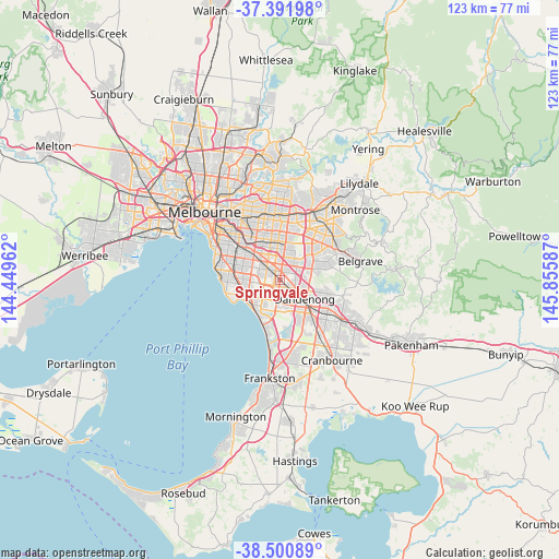
Springvale GPS coordinates[2]
37° 56' 54.708" South, 145° 9' 9.864" East
| Map corner | latitude | longitude |
|---|---|---|
| Upper-left | -37.39198°, | 144.44962° |
| Center: | -37.94853°, | 145.15274° |
| Lower-right: | -38.50089°, | 145.85587° |
| Map W x H: | 123.3×123.3 km | = 76.6×76.6mi |
| max Lat: | -10.58257° ⇑91.2% North |
| Springvale: | -37.94853° |
| min Lat: | ⇓8.8% South -43.31423° |
| min Long | Springvale | max Long |
| 113.53327° | 145.15274° | 153.61246° |
| W 36.7%⇐ | ⇒63.3% E |
Elevation
Elevation of Springvale is 55 m = 180 ft, and this is 67 m = 220 ft below average elevation for this country.
| Max E: |
1715 m = 5627 ft | 44.2% |
| Avg. | 122 m = 400 ft | |
| Springvale | 55 m = 180 ft | |
Min E: |
-2 m = -7 ft | 55.8% |
See also: Australia elevation on elevation.city.
Geographical zone
Springvale is located in South temperate zone (between Tropic of Capricorn and the Antarctic Circle). Distance of this Southern Tropic circle is 1613.6 km =1002.6 mi to North.| Distance of | km | miles | from Springvale |
|---|---|---|---|
| Equator | 4219.5 | 2621.9 | to North |
| Tropic Capricorn | 1613.6 | 1002.6 | to North |
| Antarctic Circle | 3181.7 | 1977 | to South |
| South Pole | 5787.6 | 3596.2 | to South |


Nearby cities:
15 places around Springvale: (largest is in red/bold)
• Clarinda
4.5 km =2.8 mi,  281°
281°
• Clayton
4.7 km =2.9 mi,  318°
318°
• Clayton South
3.6 km =2.2 mi,  298°
298°
• Dandenong
5.7 km =3.5 mi,  133°
133°
• Dandenong North
5.2 km =3.2 mi,  112°
112°
• Dingley Village
4.1 km =2.5 mi,  203°
203°
• Heatherton
5 km =3.1 mi,  246°
246°
• Keysborough
5.1 km =3.2 mi,  158°
158°
• Mulgrave
3.1 km =1.9 mi,  43°
43°
• Noble Park
2.4 km =1.5 mi,  148°
148°
• Noble Park North
3.5 km =2.2 mi,  92°
92°
• Notting Hill
4.9 km =3 mi,  349°
349°
• Oakleigh South
6 km =3.7 mi, 296°
• Springvale South
2 km =1.2 mi,  186°
186°
• Wheelers Hill
6 km =3.7 mi,  26°
26°
Sources, notices
• [Note1] Compared only with cities in Australia existing in our database
• [Src1] Map data: © OpenStreetMap contributors (CC-BY-SA)
• [Src2] Other city data from geonames.org with taken over terms of usage.
• [Src3] Geographical zone / Annual Mean Temperature by Robert A. Rohde @ Wikipedia
