Mulgrave geodata
Mulgrave (Victoria) is a section of populated place; located in Australia in Australia/Melbourne (GMT+11) time zone. With population of 17,647 people, there are 208 cities with bigger population in this country. Compared to other cities in Australia, 90.9% of cities are located further ↑North; 63% of cities are located further →East and 74.7% of cities have lower elevation than Mulgrave. Note1


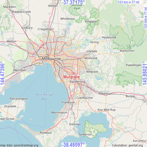
Mulgrave GPS coordinates[2]
37° 55' 42.42" South, 145° 10' 37.488" East
| Map corner | latitude | longitude |
|---|---|---|
| Upper-left | -37.37175°, | 144.47396° |
| Center: | -37.92845°, | 145.17708° |
| Lower-right: | -38.48097°, | 145.88021° |
| Map W x H: | 123.3×123.3 km | = 76.6×76.6mi |
| max Lat: | -10.58257° ⇑90.9% North |
| Mulgrave: | -37.92845° |
| min Lat: | ⇓9.1% South -43.31423° |
| min Long | Mulgrave | max Long |
| 113.53327° | 145.17708° | 153.61246° |
| W 37%⇐ | ⇒63% E |
Elevation
Elevation of Mulgrave is 128 m = 420 ft, and this is 6 m = 20 ft above average elevation for this country.
| Max E: |
1715 m = 5627 ft | 25.3% |
| Mulgrave | 128 m 420 ft | |
| Avg. | 122 m = 400 ft | |
Min E: |
-2 m = -7 ft | 74.7% |
See also: Australia elevation on elevation.city.
Geographical zone
Mulgrave is located in South temperate zone (between Tropic of Capricorn and the Antarctic Circle). Distance of this Southern Tropic circle is 1611.3 km =1001.2 mi to North.| Distance of | km | miles | from Mulgrave |
|---|---|---|---|
| Equator | 4217.2 | 2620.4 | to North |
| Tropic Capricorn | 1611.3 | 1001.2 | to North |
| Antarctic Circle | 3183.9 | 1978.4 | to South |
| South Pole | 5789.8 | 3597.6 | to South |


Nearby cities:
15 places around Mulgrave: (largest is in red/bold)
• Clayton
5.5 km =3.4 mi,  283°
283°
• Clayton South
5.3 km =3.3 mi,  264°
264°
• Dandenong
6.4 km =4 mi,  161°
161°
• Dandenong North
5 km =3.1 mi,  147°
147°
• Glen Waverley
5.7 km =3.5 mi,  349°
349°
• Noble Park
4.3 km =2.7 mi,  192°
192°
• Noble Park North
2.7 km =1.7 mi, 150°
• Notting Hill
4 km =2.5 mi,  310°
310°
• Oakleigh East
6.2 km =3.9 mi,  300°
300°
• Rowville
5 km =3.1 mi,  96°
96°
• Scoresby
5.9 km =3.7 mi,  57°
57°
• Springvale
3.1 km =1.9 mi,  223°
223°
• Springvale South
4.9 km =3 mi,  209°
209°
• Wantirna South
6.1 km =3.8 mi,  34°
34°
• Wheelers Hill
3.2 km =2 mi,  9°
9°
Sources, notices
• [Note1] Compared only with cities in Australia existing in our database
• [Src1] Map data: © OpenStreetMap contributors (CC-BY-SA)
• [Src2] Other city data from geonames.org with taken over terms of usage.
• [Src3] Geographical zone / Annual Mean Temperature by Robert A. Rohde @ Wikipedia
