Clayton geodata
Clayton (Victoria) is a section of populated place; located in Australia in Australia/Melbourne (GMT+11) time zone. With population of 20,130 people, there are 165 cities with bigger population in this country. Compared to other cities in Australia, 90.8% of cities are located further ↑North; 64.2% of cities are located further →East and 62.1% of cities have lower elevation than Clayton. Note1


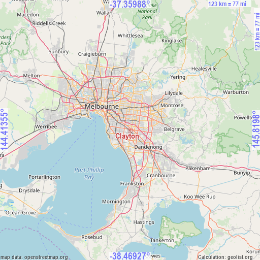
Clayton GPS coordinates[2]
37° 55' 0.012" South, 145° 7' 0.012" East
| Map corner | latitude | longitude |
|---|---|---|
| Upper-left | -37.35988°, | 144.41355° |
| Center: | -37.91667°, | 145.11667° |
| Lower-right: | -38.46927°, | 145.8198° |
| Map W x H: | 123.4×123.4 km | = 76.7×76.7mi |
| max Lat: | -10.58257° ⇑90.8% North |
| Clayton: | -37.91667° |
| min Lat: | ⇓9.2% South -43.31423° |
| min Long | Clayton | max Long |
| 113.53327° | 145.11667° | 153.61246° |
| W 35.8%⇐ | ⇒64.2% E |
Elevation
Elevation of Clayton is 70 m = 230 ft, and this is 52 m = 171 ft below average elevation for this country.
| Max E: |
1715 m = 5627 ft | 37.9% |
| Avg. | 122 m = 400 ft | |
| Clayton | 70 m = 230 ft | |
Min E: |
-2 m = -7 ft | 62.1% |
See also: Australia elevation on elevation.city.
Geographical zone
Clayton is located in South temperate zone (between Tropic of Capricorn and the Antarctic Circle). Distance of this Southern Tropic circle is 1610 km =1000.4 mi to North.| Distance of | km | miles | from Clayton |
|---|---|---|---|
| Equator | 4215.9 | 2619.6 | to North |
| Tropic Capricorn | 1610 | 1000.4 | to North |
| Antarctic Circle | 3185.2 | 1979.2 | to South |
| South Pole | 5791.1 | 3598.4 | to South |


Nearby cities:
15 places around Clayton: (largest is in red/bold)
• Bentleigh East
5.6 km =3.5 mi,  267°
267°
• Chadstone
3.7 km =2.3 mi,  329°
329°
• Clarinda
2.9 km =1.8 mi,  205°
205°
• Clayton South
1.9 km =1.2 mi,  180°
180°
• Heatherton
5.7 km =3.5 mi,  194°
194°
• Hughesdale
3.5 km =2.2 mi,  302°
302°
• Huntingdale
1.2 km =0.7 mi,  324°
324°
• Mount Waverley
4.5 km =2.8 mi,  14°
14°
• Mulgrave
5.5 km =3.4 mi,  103°
103°
• Murrumbeena
4.8 km =3 mi,  292°
292°
• Notting Hill
2.6 km =1.6 mi,  60°
60°
• Oakleigh
3.2 km =2 mi,  309°
309°
• Oakleigh East
1.9 km =1.2 mi,  0°
0°
• Oakleigh South
2.4 km =1.5 mi,  249°
249°
• Springvale
4.7 km =2.9 mi,  138°
138°
Sources, notices
• [Note1] Compared only with cities in Australia existing in our database
• [Src1] Map data: © OpenStreetMap contributors (CC-BY-SA)
• [Src2] Other city data from geonames.org with taken over terms of usage.
• [Src3] Geographical zone / Annual Mean Temperature by Robert A. Rohde @ Wikipedia
