South Arm geodata
South Arm (Tasmania) is a populated place; located in Australia in Australia/Hobart (GMT+11) time zone. With population of 796 people, there are 4158 cities with bigger population in this country. Compared to other cities in Australia, 99.8% of cities are located further ↑North; 50.2% of cities are located further →East and 99.9% of cities have higher elevation than South Arm. Note1


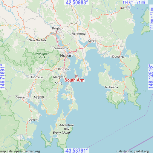
South Arm GPS coordinates[2]
43° 1' 33.78" South, 147° 25' 19.308" East
| Map corner | latitude | longitude |
|---|---|---|
| Upper-left | -42.50988°, | 146.71891° |
| Center: | -43.02605°, | 147.42203° |
| Lower-right: | -43.53791°, | 148.12516° |
| Map W x H: | 114.3×114.3 km | = 71×71mi |
| max Lat: | -10.58257° ⇑99.8% North |
| South Arm: | -43.02605° |
| min Lat: | ⇓0.2% South -43.31423° |
| min Long | South Arm | max Long |
| 113.53327° | 147.42203° | 153.61246° |
| W 49.8%⇐ | ⇒50.2% E |
Elevation
Elevation of South Arm is 1 m = 3 ft, and this is 121 m = 397 ft below average elevation for this country.
| Max E: |
1715 m = 5627 ft | 99.9% |
| Avg. | 122 m = 400 ft | |
| South Arm | 1 m = 3 ft | |
Min E: |
-2 m = -7 ft | 0.1% |
See also: Australia elevation on elevation.city.
Geographical zone
South Arm is located in South temperate zone (between Tropic of Capricorn and the Antarctic Circle). Distance of this Southern Tropic circle is 2178.1 km =1353.4 mi to North.| Distance of | km | miles | from South Arm |
|---|---|---|---|
| Equator | 4784 | 2972.6 | to North |
| Tropic Capricorn | 2178.1 | 1353.4 | to North |
| Antarctic Circle | 2617.1 | 1626.2 | to South |
| South Pole | 5223 | 3245.4 | to South |


Nearby cities:
15 places around South Arm: (largest is in red/bold)
• Blackmans Bay
8.9 km =5.5 mi,  286°
286°
• Clifton Beach
9.2 km =5.7 mi,  60°
60°
• Cremorne
11.7 km =7.3 mi,  49°
49°
• Howden
10.4 km =6.5 mi,  270°
270°
• Kingston
11.1 km =6.9 mi,  299°
299°
• Kingston Beach
9.8 km =6.1 mi, 301°
• Lauderdale
13.6 km =8.5 mi,  23°
23°
• Margate
13 km =8.1 mi, 268°
• Mount Nelson
14.3 km =8.9 mi,  324°
324°
• Oakdowns
14.1 km =8.8 mi,  11°
11°
• Rokeby
14.3 km =8.9 mi, 8°
• Sandford
12.1 km =7.5 mi,  31°
31°
• Snug
14.3 km =8.9 mi,  251°
251°
• Taroona
10.8 km =6.7 mi,  326°
326°
• Tranmere
11.6 km =7.2 mi,  357°
357°
Sources, notices
• [Note1] Compared only with cities in Australia existing in our database
• [Src1] Map data: © OpenStreetMap contributors (CC-BY-SA)
• [Src2] Other city data from geonames.org with taken over terms of usage.
• [Src3] Geographical zone / Annual Mean Temperature by Robert A. Rohde @ Wikipedia
