Howden geodata
Howden (Tasmania) is a section of populated place; located in Australia in Australia/Hobart (GMT+11) time zone. With population of 655 people, there are 4423 cities with bigger population in this country. Compared to other cities in Australia, 99.8% of cities are located further ↑North; 51.2% of cities are located further →East and 62.8% of cities have higher elevation than Howden. Note1


Howden GPS coordinates[2]
43° 1' 31.368" South, 147° 17' 37.176" East
| Map corner | latitude | longitude |
|---|---|---|
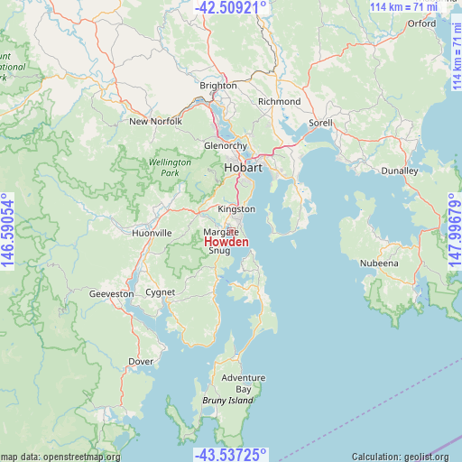
| Upper-left | -42.50921°, | 146.59054° |
| Center: | -43.02538°, | 147.29366° |
| Lower-right: | -43.53725°, | 147.99679° |
| Map W x H: | 114.3×114.3 km | = 71×71mi |
| max Lat: | -10.58257° ⇑99.8% North |
| Howden: | -43.02538° |
| min Lat: | ⇓0.2% South -43.31423° |
| min Long | Howden | max Long |
| 113.53327° | 147.29366° | 153.61246° |
| W 48.8%⇐ | ⇒51.2% E |
Elevation
Elevation of Howden is 29 m = 95 ft, and this is 93 m = 305 ft below average elevation for this country.
| Max E: |
1715 m = 5627 ft | 62.8% |
| Avg. | 122 m = 400 ft | |
| Howden | 29 m = 95 ft | |
Min E: |
-2 m = -7 ft | 37.2% |
See also: Australia elevation on elevation.city.
Geographical zone
Howden is located in South temperate zone (between Tropic of Capricorn and the Antarctic Circle). Distance of this Southern Tropic circle is 2178.1 km =1353.4 mi to North.| Distance of | km | miles | from Howden |
|---|---|---|---|
| Equator | 4784 | 2972.6 | to North |
| Tropic Capricorn | 2178.1 | 1353.4 | to North |
| Antarctic Circle | 2617.2 | 1626.3 | to South |
| South Pole | 5223.1 | 3245.5 | to South |


Nearby cities:
15 places around Howden: (largest is in red/bold)
• Blackmans Bay
3.1 km =1.9 mi,  37°
37°
• Dynnyrne
13.5 km =8.4 mi,  7°
7°
• Fern Tree
11.9 km =7.4 mi,  348°
348°
• Kettering
11.9 km =7.4 mi,  198°
198°
• Kingston
5.5 km =3.4 mi, 8°
• Kingston Beach
5.4 km =3.4 mi,  22°
22°
• Margate
2.5 km =1.6 mi,  263°
263°
• Mount Nelson
11.8 km =7.3 mi, 10°
• Sandy Bay
14.8 km =9.2 mi, 9°
• Snug
5.6 km =3.5 mi,  214°
214°
• South Arm
10.4 km =6.5 mi,  90°
90°
• South Hobart
14.6 km =9.1 mi,  4°
4°
• Taroona
10 km =6.2 mi,  26°
26°
• Tolmans Hill
12.4 km =7.7 mi, 5°
• Tranmere
15.3 km =9.5 mi, 41°
Sources, notices
• [Note1] Compared only with cities in Australia existing in our database
• [Src1] Map data: © OpenStreetMap contributors (CC-BY-SA)
• [Src2] Other city data from geonames.org with taken over terms of usage.
• [Src3] Geographical zone / Annual Mean Temperature by Robert A. Rohde @ Wikipedia
