Smithfield geodata
Smithfield (New South Wales) is a section of populated place; located in Australia in Australia/Sydney (GMT+11) time zone. With population of 11,899 people, there are 426 cities with bigger population in this country. Compared to other cities in Australia, 53.8% of cities are located further ↑North; 66.3% of cities are located further ←West and 62.8% of cities have higher elevation than Smithfield. Note1


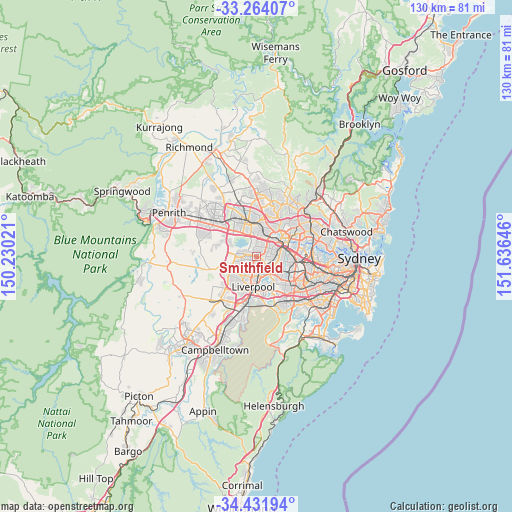
Smithfield GPS coordinates[2]
33° 51' 0" South, 150° 55' 59.988" East
| Map corner | latitude | longitude |
|---|---|---|
| Upper-left | -33.26407°, | 150.23021° |
| Center: | -33.85°, | 150.93333° |
| Lower-right: | -34.43194°, | 151.63646° |
| Map W x H: | 129.9×129.9 km | = 80.7×80.7mi |
| max Lat: | -10.58257° ⇑53.8% North |
| Smithfield: | -33.85° |
| min Lat: | ⇓46.2% South -43.31423° |
| min Long | Smithfield | max Long |
| 113.53327° | 150.93333° | 153.61246° |
| W 66.3%⇐ | ⇒33.7% E |
Elevation
Elevation of Smithfield is 29 m = 95 ft, and this is 93 m = 305 ft below average elevation for this country.
| Max E: |
1715 m = 5627 ft | 62.8% |
| Avg. | 122 m = 400 ft | |
| Smithfield | 29 m = 95 ft | |
Min E: |
-2 m = -7 ft | 37.2% |
See also: Australia elevation on elevation.city.
Geographical zone
Smithfield is located in South temperate zone (between Tropic of Capricorn and the Antarctic Circle). Distance of this Southern Tropic circle is 1157.8 km =719.4 mi to North.| Distance of | km | miles | from Smithfield |
|---|---|---|---|
| Equator | 3763.8 | 2338.7 | to North |
| Tropic Capricorn | 1157.8 | 719.4 | to North |
| Antarctic Circle | 3637.4 | 2260.2 | to South |
| South Pole | 6243.3 | 3879.4 | to South |


Nearby cities:
15 places around Smithfield: (largest is in red/bold)
• Canley Heights
3.7 km =2.3 mi,  193°
193°
• Canley Vale
4.3 km =2.7 mi,  161°
161°
• Fairfield
2.4 km =1.5 mi,  140°
140°
• Fairfield East
4.1 km =2.5 mi,  121°
121°
• Fairfield Heights
1.7 km =1.1 mi, 162°
• Fairfield West
2.4 km =1.5 mi,  219°
219°
• Greystanes
3.2 km =2 mi,  21°
21°
• Guildford West
2.9 km =1.8 mi,  88°
88°
• Merrylands West
3.8 km =2.4 mi,  59°
59°
• Pemulwuy
3.2 km =2 mi,  344°
344°
• Prairiewood
3 km =1.9 mi,  240°
240°
• Wakeley
3.5 km =2.2 mi, 218°
• Wetherill Park
3.1 km =1.9 mi,  284°
284°
• Woodpark
2.7 km =1.7 mi,  69°
69°
• Yennora
3.5 km =2.2 mi,  111°
111°
Sources, notices
• [Note1] Compared only with cities in Australia existing in our database
• [Src1] Map data: © OpenStreetMap contributors (CC-BY-SA)
• [Src2] Other city data from geonames.org with taken over terms of usage.
• [Src3] Geographical zone / Annual Mean Temperature by Robert A. Rohde @ Wikipedia
