Wakeley geodata
Wakeley (New South Wales) is a section of populated place; located in Australia in Australia/Sydney (GMT+11) time zone. With population of 4,740 people, there are 1554 cities with bigger population in this country. Compared to other cities in Australia, 54.7% of cities are located further ↑North; 65.7% of cities are located further ←West and 62.8% of cities have higher elevation than Wakeley. Note1


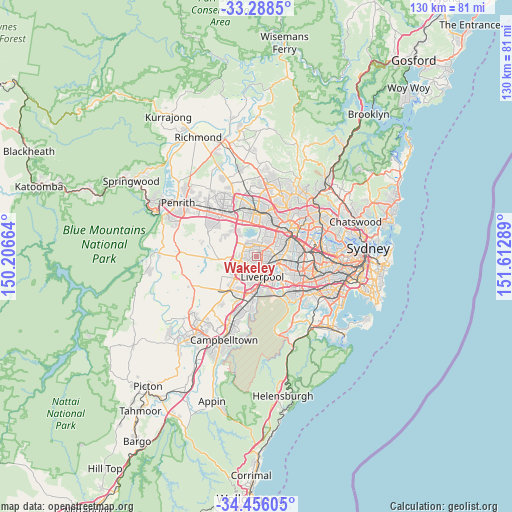
Wakeley GPS coordinates[2]
33° 52' 27.372" South, 150° 54' 35.136" East
| Map corner | latitude | longitude |
|---|---|---|
| Upper-left | -33.2885°, | 150.20664° |
| Center: | -33.87427°, | 150.90976° |
| Lower-right: | -34.45605°, | 151.61289° |
| Map W x H: | 129.8×129.8 km | = 80.7×80.7mi |
| max Lat: | -10.58257° ⇑54.7% North |
| Wakeley: | -33.87427° |
| min Lat: | ⇓45.3% South -43.31423° |
| min Long | Wakeley | max Long |
| 113.53327° | 150.90976° | 153.61246° |
| W 65.7%⇐ | ⇒34.3% E |
Elevation
Elevation of Wakeley is 29 m = 95 ft, and this is 93 m = 305 ft below average elevation for this country.
| Max E: |
1715 m = 5627 ft | 62.8% |
| Avg. | 122 m = 400 ft | |
| Wakeley | 29 m = 95 ft | |
Min E: |
-2 m = -7 ft | 37.2% |
See also: Australia elevation on elevation.city.
Geographical zone
Wakeley is located in South temperate zone (between Tropic of Capricorn and the Antarctic Circle). Distance of this Southern Tropic circle is 1160.5 km =721.1 mi to North.| Distance of | km | miles | from Wakeley |
|---|---|---|---|
| Equator | 3766.5 | 2340.4 | to North |
| Tropic Capricorn | 1160.5 | 721.1 | to North |
| Antarctic Circle | 3634.7 | 2258.5 | to South |
| South Pole | 6240.6 | 3877.7 | to South |


Nearby cities:
15 places around Wakeley: (largest is in red/bold)
• Bonnyrigg
2.9 km =1.8 mi,  221°
221°
• Bossley Park
2.7 km =1.7 mi,  300°
300°
• Cabramatta
3.4 km =2.1 mi,  138°
138°
• Cabramatta West
2.1 km =1.3 mi,  174°
174°
• Canley Heights
1.6 km =1 mi,  125°
125°
• Edensor Park
3 km =1.9 mi,  258°
258°
• Fairfield
3.8 km =2.4 mi,  77°
77°
• Fairfield Heights
2.9 km =1.8 mi,  67°
67°
• Fairfield West
1.1 km =0.7 mi,  38°
38°
• Greenfield Park
1.7 km =1.1 mi,  268°
268°
• Mount Pritchard
3.2 km =2 mi,  188°
188°
• Prairiewood
1.3 km =0.8 mi,  341°
341°
• Smithfield
3.5 km =2.2 mi, 38°
• St Johns Park
1.2 km =0.7 mi, 217°
• Wetherill Park
3.6 km =2.2 mi,  346°
346°
Sources, notices
• [Note1] Compared only with cities in Australia existing in our database
• [Src1] Map data: © OpenStreetMap contributors (CC-BY-SA)
• [Src2] Other city data from geonames.org with taken over terms of usage.
• [Src3] Geographical zone / Annual Mean Temperature by Robert A. Rohde @ Wikipedia
