Sedgwick geodata
Sedgwick (Victoria) is a populated place; located in Australia in Australia/Melbourne (GMT+11) time zone. With population of 533 people, there are 4770 cities with bigger population in this country. Compared to other cities in Australia, 81.2% of cities are located further ↑North; 71.3% of cities are located further →East and 86.4% of cities have lower elevation than Sedgwick. Note1


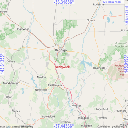
Sedgwick GPS coordinates[2]
36° 52' 59.988" South, 144° 19' 0.012" East
| Map corner | latitude | longitude |
|---|---|---|
| Upper-left | -36.31886°, | 143.61355° |
| Center: | -36.88333°, | 144.31667° |
| Lower-right: | -37.44366°, | 145.0198° |
| Map W x H: | 125.1×125.1 km | = 77.7×77.7mi |
| max Lat: | -10.58257° ⇑81.2% North |
| Sedgwick: | -36.88333° |
| min Lat: | ⇓18.8% South -43.31423° |
| min Long | Sedgwick | max Long |
| 113.53327° | 144.31667° | 153.61246° |
| W 28.7%⇐ | ⇒71.3% E |
Elevation
Elevation of Sedgwick is 275 m = 902 ft, and this is 153 m = 502 ft above average elevation for this country.
| Max E: |
1715 m = 5627 ft | 13.6% |
| Sedgwick | 275 m 902 ft | |
| Avg. | 122 m = 400 ft | |
Min E: |
-2 m = -7 ft | 86.4% |
See also: Australia elevation on elevation.city.
Geographical zone
Sedgwick is located in South temperate zone (between Tropic of Capricorn and the Antarctic Circle). Distance of this Southern Tropic circle is 1495.1 km =929 mi to North.| Distance of | km | miles | from Sedgwick |
|---|---|---|---|
| Equator | 4101 | 2548.2 | to North |
| Tropic Capricorn | 1495.1 | 929 | to North |
| Antarctic Circle | 3300.1 | 2050.6 | to South |
| South Pole | 5906 | 3669.8 | to South |


Nearby cities:
15 places around Sedgwick: (largest is in red/bold)
• Bendigo
14.3 km =8.9 mi,  346°
346°
• Bendigo city centre
14.4 km =8.9 mi, 346°
• Eppalock
13.2 km =8.2 mi,  75°
75°
• Flora Hill
11.5 km =7.1 mi, 350°
• Golden Square
13.6 km =8.5 mi,  335°
335°
• Harcourt
13.9 km =8.6 mi,  201°
201°
• Ironbark
15 km =9.3 mi, 341°
• Junortoun
13.1 km =8.1 mi,  18°
18°
• Kangaroo Flat
11 km =6.8 mi,  327°
327°
• Kennington
12.5 km =7.8 mi, 354°
• Lockwood South
14.8 km =9.2 mi,  287°
287°
• Mandurang
7.6 km =4.7 mi, 348°
• Quarry Hill
12.3 km =7.6 mi, 344°
• Strathdale
13.1 km =8.1 mi,  359°
359°
• Strathfieldsaye
9.2 km =5.7 mi, 21°
Sources, notices
• [Note1] Compared only with cities in Australia existing in our database
• [Src1] Map data: © OpenStreetMap contributors (CC-BY-SA)
• [Src2] Other city data from geonames.org with taken over terms of usage.
• [Src3] Geographical zone / Annual Mean Temperature by Robert A. Rohde @ Wikipedia
