Eppalock geodata
Eppalock (Victoria) is a populated place; located in Australia in Australia/Melbourne (GMT+11) time zone. With population of 650 people, there are 4441 cities with bigger population in this country. Compared to other cities in Australia, 81.2% of cities are located further ↑North; 70.3% of cities are located further →East and 83.4% of cities have lower elevation than Eppalock. Note1


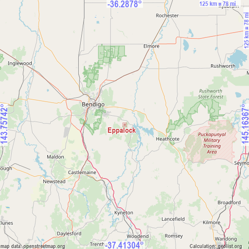
Eppalock GPS coordinates[2]
36° 51' 8.964" South, 144° 27' 37.944" East
| Map corner | latitude | longitude |
|---|---|---|
| Upper-left | -36.2878°, | 143.75742° |
| Center: | -36.85249°, | 144.46054° |
| Lower-right: | -37.41304°, | 145.16367° |
| Map W x H: | 125.1×125.1 km | = 77.7×77.7mi |
| max Lat: | -10.58257° ⇑81.2% North |
| Eppalock: | -36.85249° |
| min Lat: | ⇓18.8% South -43.31423° |
| min Long | Eppalock | max Long |
| 113.53327° | 144.46054° | 153.61246° |
| W 29.7%⇐ | ⇒70.3% E |
Elevation
Elevation of Eppalock is 223 m = 732 ft, and this is 101 m = 331 ft above average elevation for this country.
| Max E: |
1715 m = 5627 ft | 16.6% |
| Eppalock | 223 m 732 ft | |
| Avg. | 122 m = 400 ft | |
Min E: |
-2 m = -7 ft | 83.4% |
See also: Australia elevation on elevation.city.
Geographical zone
Eppalock is located in South temperate zone (between Tropic of Capricorn and the Antarctic Circle). Distance of this Southern Tropic circle is 1491.7 km =926.9 mi to North.| Distance of | km | miles | from Eppalock |
|---|---|---|---|
| Equator | 4097.6 | 2546.1 | to North |
| Tropic Capricorn | 1491.7 | 926.9 | to North |
| Antarctic Circle | 3303.6 | 2052.8 | to South |
| South Pole | 5909.4 | 3671.9 | to South |


Nearby cities:
15 places around Eppalock: (largest is in red/bold)
• Axedale
7.7 km =4.8 mi,  40°
40°
• Bendigo
19.2 km =11.9 mi,  303°
303°
• Bendigo city centre
19.3 km =12 mi, 303°
• East Bendigo
17.6 km =10.9 mi,  314°
314°
• Flora Hill
16.7 km =10.4 mi, 298°
• Junortoun
12.5 km =7.8 mi,  316°
316°
• Kangaroo Flat
19.6 km =12.2 mi,  287°
287°
• Kennington
16.7 km =10.4 mi, 302°
• Mandurang
14.8 km =9.2 mi, 285°
• North Bendigo
19.6 km =12.2 mi, 308°
• Quarry Hill
18.1 km =11.2 mi, 297°
• Sedgwick
13.2 km =8.2 mi,  255°
255°
• Strathdale
16.1 km =10 mi, 306°
• Strathfieldsaye
10.7 km =6.6 mi, 298°
• White Hills
19.5 km =12.1 mi, 314°
Sources, notices
• [Note1] Compared only with cities in Australia existing in our database
• [Src1] Map data: © OpenStreetMap contributors (CC-BY-SA)
• [Src2] Other city data from geonames.org with taken over terms of usage.
• [Src3] Geographical zone / Annual Mean Temperature by Robert A. Rohde @ Wikipedia
