Saint Leonards geodata
Saint Leonards (Tasmania) is a section of populated place; located in Australia in Australia/Hobart (GMT+11) time zone. With population of 1,977 people, there are 2925 cities with bigger population in this country. Compared to other cities in Australia, 97.6% of cities are located further ↑North; 51.9% of cities are located further →East and 75.4% of cities have lower elevation than Saint Leonards. Note1


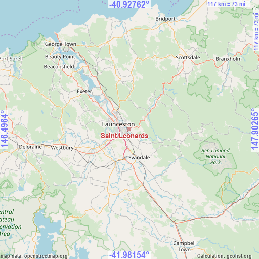
Saint Leonards GPS coordinates[2]
41° 27' 24.192" South, 147° 11' 58.272" East
| Map corner | latitude | longitude |
|---|---|---|
| Upper-left | -40.92762°, | 146.4964° |
| Center: | -41.45672°, | 147.19952° |
| Lower-right: | -41.98154°, | 147.90265° |
| Map W x H: | 117.2×117.2 km | = 72.8×72.8mi |
| max Lat: | -10.58257° ⇑97.6% North |
| Saint Leonards: | -41.45672° |
| min Lat: | ⇓2.4% South -43.31423° |
| min Long | Saint Leonards | max Long |
| 113.53327° | 147.19952° | 153.61246° |
| W 48.1%⇐ | ⇒51.9% E |
Elevation
Elevation of Saint Leonards is 135 m = 443 ft, and this is 13 m = 43 ft above average elevation for this country.
| Max E: |
1715 m = 5627 ft | 24.6% |
| Saint Leonards | 135 m 443 ft | |
| Avg. | 122 m = 400 ft | |
Min E: |
-2 m = -7 ft | 75.4% |
See also: Australia elevation on elevation.city.
Geographical zone
Saint Leonards is located in South temperate zone (between Tropic of Capricorn and the Antarctic Circle). Distance of this Southern Tropic circle is 2003.6 km =1245 mi to North.| Distance of | km | miles | from Saint Leonards |
|---|---|---|---|
| Equator | 4609.6 | 2864.3 | to North |
| Tropic Capricorn | 2003.6 | 1245 | to North |
| Antarctic Circle | 2791.6 | 1734.6 | to South |
| South Pole | 5397.5 | 3353.8 | to South |


Nearby cities:
15 places around Saint Leonards: (largest is in red/bold)
• East Launceston
4.5 km =2.8 mi,  296°
296°
• Invermay
6.8 km =4.2 mi,  306°
306°
• Kings Meadows
3.5 km =2.2 mi,  244°
244°
• Launceston
5.8 km =3.6 mi,  290°
290°
• Launceston city centre
5.8 km =3.6 mi, 296°
• Mowbray
7.3 km =4.5 mi,  325°
325°
• Newstead
3.6 km =2.2 mi, 298°
• Norwood
1.6 km =1 mi,  259°
259°
• Ravenswood
4.8 km =3 mi,  342°
342°
• South Launceston
4.5 km =2.8 mi,  272°
272°
• Summerhill
6.1 km =3.8 mi, 258°
• Trevallyn
8 km =5 mi,  281°
281°
• Waverley
2.6 km =1.6 mi, 333°
• West Launceston
5.7 km =3.5 mi, 276°
• Youngtown
3.8 km =2.4 mi,  219°
219°
Sources, notices
• [Note1] Compared only with cities in Australia existing in our database
• [Src1] Map data: © OpenStreetMap contributors (CC-BY-SA)
• [Src2] Other city data from geonames.org with taken over terms of usage.
• [Src3] Geographical zone / Annual Mean Temperature by Robert A. Rohde @ Wikipedia
