Penshurst geodata
Penshurst (New South Wales) is a section of populated place; located in Australia in Australia/Sydney (GMT+10) time zone. With population of 12,673 people, there are 371 cities with bigger population in this country. Compared to other cities in Australia, 58.2% of cities are located further ↑North; 69.4% of cities are located further ←West and 59.6% of cities have lower elevation than Penshurst. Note1


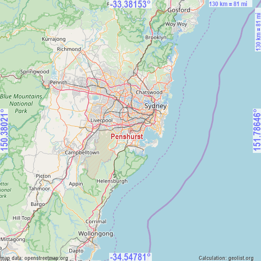
Penshurst GPS coordinates[2]
33° 58' 0.012" South, 151° 4' 59.988" East
| Map corner | latitude | longitude |
|---|---|---|
| Upper-left | -33.38153°, | 150.38021° |
| Center: | -33.96667°, | 151.08333° |
| Lower-right: | -34.54781°, | 151.78646° |
| Map W x H: | 129.7×129.7 km | = 80.6×80.6mi |
| max Lat: | -10.58257° ⇑58.2% North |
| Penshurst: | -33.96667° |
| min Lat: | ⇓41.8% South -43.31423° |
| min Long | Penshurst | max Long |
| 113.53327° | 151.08333° | 153.61246° |
| W 69.4%⇐ | ⇒30.6% E |
Elevation
Elevation of Penshurst is 63 m = 207 ft, and this is 59 m = 194 ft below average elevation for this country.
| Max E: |
1715 m = 5627 ft | 40.4% |
| Avg. | 122 m = 400 ft | |
| Penshurst | 63 m = 207 ft | |
Min E: |
-2 m = -7 ft | 59.6% |
See also: Australia elevation on elevation.city.
Geographical zone
Penshurst is located in South temperate zone (between Tropic of Capricorn and the Antarctic Circle). Distance of this Southern Tropic circle is 1170.8 km =727.5 mi to North.| Distance of | km | miles | from Penshurst |
|---|---|---|---|
| Equator | 3776.7 | 2346.7 | to North |
| Tropic Capricorn | 1170.8 | 727.5 | to North |
| Antarctic Circle | 3624.4 | 2252.1 | to South |
| South Pole | 6230.3 | 3871.3 | to South |


Nearby cities:
15 places around Penshurst: (largest is in red/bold)
• Allawah
2.9 km =1.8 mi,  102°
102°
• Beverly Hills
2.1 km =1.3 mi,  351°
351°
• Bexley
3.6 km =2.2 mi,  58°
58°
• Carlton
3.5 km =2.2 mi, 97°
• Connells Point
2.5 km =1.6 mi,  163°
163°
• Hurstville
1.7 km =1.1 mi,  93°
93°
• Hurstville Grove
1.6 km =1 mi, 156°
• Kingsgrove
3.4 km =2.1 mi,  25°
25°
• Kyle Bay
2.8 km =1.7 mi,  147°
147°
• Mortdale
1 km =0.6 mi,  255°
255°
• Narwee
2.6 km =1.6 mi,  329°
329°
• Oatley
1.8 km =1.1 mi,  215°
215°
• Peakhurst
3 km =1.9 mi,  278°
278°
• Peakhurst Heights
2.8 km =1.7 mi,  245°
245°
• South Hurstville
2.4 km =1.5 mi,  120°
120°
Sources, notices
• [Note1] Compared only with cities in Australia existing in our database
• [Src1] Map data: © OpenStreetMap contributors (CC-BY-SA)
• [Src2] Other city data from geonames.org with taken over terms of usage.
• [Src3] Geographical zone / Annual Mean Temperature by Robert A. Rohde @ Wikipedia
