Allawah geodata
Allawah (New South Wales) is a section of populated place; located in Australia in Australia/Sydney (GMT+10) time zone. With population of 5,645 people, there are 1300 cities with bigger population in this country. Compared to other cities in Australia, 58.4% of cities are located further ↑North; 70.4% of cities are located further ←West and 54.5% of cities have higher elevation than Allawah. Note1


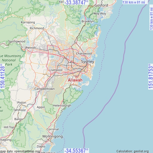
Allawah GPS coordinates[2]
33° 58' 21.252" South, 151° 6' 51.84" East
| Map corner | latitude | longitude |
|---|---|---|
| Upper-left | -33.38747°, | 150.41128° |
| Center: | -33.97257°, | 151.1144° |
| Lower-right: | -34.55367°, | 151.81753° |
| Map W x H: | 129.7×129.7 km | = 80.6×80.6mi |
| max Lat: | -10.58257° ⇑58.4% North |
| Allawah: | -33.97257° |
| min Lat: | ⇓41.6% South -43.31423° |
| min Long | Allawah | max Long |
| 113.53327° | 151.1144° | 153.61246° |
| W 70.4%⇐ | ⇒29.6% E |
Elevation
Elevation of Allawah is 39 m = 128 ft, and this is 83 m = 272 ft below average elevation for this country.
| Max E: |
1715 m = 5627 ft | 54.5% |
| Avg. | 122 m = 400 ft | |
| Allawah | 39 m = 128 ft | |
Min E: |
-2 m = -7 ft | 45.5% |
See also: Australia elevation on elevation.city.
Geographical zone
Allawah is located in South temperate zone (between Tropic of Capricorn and the Antarctic Circle). Distance of this Southern Tropic circle is 1171.5 km =727.9 mi to North.| Distance of | km | miles | from Allawah |
|---|---|---|---|
| Equator | 3777.4 | 2347.2 | to North |
| Tropic Capricorn | 1171.5 | 727.9 | to North |
| Antarctic Circle | 3623.8 | 2251.7 | to South |
| South Pole | 6229.7 | 3871 | to South |


Nearby cities:
15 places around Allawah: (largest is in red/bold)
• Beverley Park
1.9 km =1.2 mi,  105°
105°
• Bexley
2.5 km =1.6 mi,  4°
4°
• Blakehurst
2.2 km =1.4 mi,  193°
193°
• Carlton
0.7 km =0.4 mi,  75°
75°
• Carss Park
1.6 km =1 mi,  170°
170°
• Connells Point
2.8 km =1.7 mi,  231°
231°
• Hurstville
1.3 km =0.8 mi,  294°
294°
• Hurstville Grove
2.4 km =1.5 mi,  249°
249°
• Kogarah
2 km =1.2 mi, 75°
• Kogarah Bay
1 km =0.6 mi,  140°
140°
• Kyle Bay
2.2 km =1.4 mi,  219°
219°
• Penshurst
2.9 km =1.8 mi,  282°
282°
• Ramsgate
2.6 km =1.6 mi, 114°
• Sans Souci
2.6 km =1.6 mi, 137°
• South Hurstville
1 km =0.6 mi,  235°
235°
Sources, notices
• [Note1] Compared only with cities in Australia existing in our database
• [Src1] Map data: © OpenStreetMap contributors (CC-BY-SA)
• [Src2] Other city data from geonames.org with taken over terms of usage.
• [Src3] Geographical zone / Annual Mean Temperature by Robert A. Rohde @ Wikipedia
