Narwee geodata
Narwee (New South Wales) is a section of populated place; located in Australia in Australia/Sydney (GMT+11) time zone. With population of 5,636 people, there are 1303 cities with bigger population in this country. Compared to other cities in Australia, 57.7% of cities are located further ↑North; 68.9% of cities are located further ←West and 51.7% of cities have higher elevation than Narwee. Note1


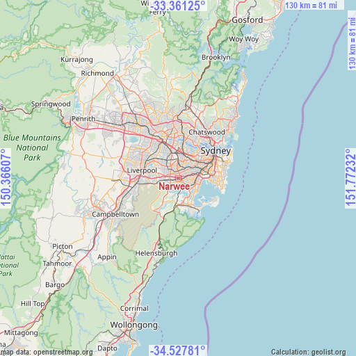
Narwee GPS coordinates[2]
33° 56' 47.508" South, 151° 4' 9.084" East
| Map corner | latitude | longitude |
|---|---|---|
| Upper-left | -33.36125°, | 150.36607° |
| Center: | -33.94653°, | 151.06919° |
| Lower-right: | -34.52781°, | 151.77232° |
| Map W x H: | 129.7×129.7 km | = 80.6×80.6mi |
| max Lat: | -10.58257° ⇑57.7% North |
| Narwee: | -33.94653° |
| min Lat: | ⇓42.3% South -43.31423° |
| min Long | Narwee | max Long |
| 113.53327° | 151.06919° | 153.61246° |
| W 68.9%⇐ | ⇒31.1% E |
Elevation
Elevation of Narwee is 43 m = 141 ft, and this is 79 m = 259 ft below average elevation for this country.
| Max E: |
1715 m = 5627 ft | 51.7% |
| Avg. | 122 m = 400 ft | |
| Narwee | 43 m = 141 ft | |
Min E: |
-2 m = -7 ft | 48.3% |
See also: Australia elevation on elevation.city.
Geographical zone
Narwee is located in South temperate zone (between Tropic of Capricorn and the Antarctic Circle). Distance of this Southern Tropic circle is 1168.6 km =726.1 mi to North.| Distance of | km | miles | from Narwee |
|---|---|---|---|
| Equator | 3774.5 | 2345.4 | to North |
| Tropic Capricorn | 1168.6 | 726.1 | to North |
| Antarctic Circle | 3626.7 | 2253.5 | to South |
| South Pole | 6232.6 | 3872.8 | to South |


Nearby cities:
15 places around Narwee: (largest is in red/bold)
• Belmore
3.6 km =2.2 mi,  31°
31°
• Beverly Hills
1 km =0.6 mi,  99°
99°
• Kingsgrove
2.9 km =1.8 mi,  73°
73°
• Lakemba
3 km =1.9 mi,  11°
11°
• Mortdale
2.5 km =1.6 mi,  173°
173°
• Oatley
3.7 km =2.3 mi,  176°
176°
• Padstow
3.6 km =2.2 mi,  251°
251°
• Padstow Heights
3.6 km =2.2 mi,  229°
229°
• Peakhurst
2.4 km =1.5 mi,  221°
221°
• Peakhurst Heights
3.6 km =2.2 mi,  200°
200°
• Penshurst
2.6 km =1.6 mi,  149°
149°
• Punchbowl
2.6 km =1.6 mi,  319°
319°
• Riverwood
1.8 km =1.1 mi,  267°
267°
• Roselands
1.5 km =0.9 mi, 13°
• Wiley Park
2.5 km =1.6 mi,  356°
356°
Sources, notices
• [Note1] Compared only with cities in Australia existing in our database
• [Src1] Map data: © OpenStreetMap contributors (CC-BY-SA)
• [Src2] Other city data from geonames.org with taken over terms of usage.
• [Src3] Geographical zone / Annual Mean Temperature by Robert A. Rohde @ Wikipedia
