Nundle geodata
Nundle (New South Wales) is a populated place; located in Australia in Australia/Sydney (GMT+11) time zone. With population of 517 people, there are 4825 cities with bigger population in this country. Compared to other cities in Australia, 69.8% of cities are located further ↓South; 70.9% of cities are located further ←West and 95.9% of cities have lower elevation than Nundle. Note1


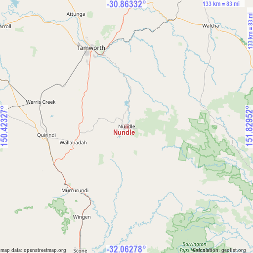
Nundle GPS coordinates[2]
31° 27' 53.892" South, 151° 7' 35.004" East
| Map corner | latitude | longitude |
|---|---|---|
| Upper-left | -30.86332°, | 150.42327° |
| Center: | -31.46497°, | 151.12639° |
| Lower-right: | -32.06278°, | 151.82952° |
| Map W x H: | 133.4×133.4 km | = 82.9×82.9mi |
| max Lat: | -10.58257° ⇑30.2% North |
| Nundle: | -31.46497° |
| min Lat: | ⇓69.8% South -43.31423° |
| min Long | Nundle | max Long |
| 113.53327° | 151.12639° | 153.61246° |
| W 70.9%⇐ | ⇒29.1% E |
Elevation
Elevation of Nundle is 601 m = 1972 ft, and this is 479 m = 1572 ft above average elevation for this country.
| Max E: |
1715 m = 5627 ft | 4.1% |
| Nundle | 601 m 1972 ft | |
| Avg. | 122 m = 400 ft | |
Min E: |
-2 m = -7 ft | 95.9% |
See also: Australia elevation on elevation.city.
Geographical zone
Nundle is located in South temperate zone (between Tropic of Capricorn and the Antarctic Circle). Distance of this Southern Tropic circle is 892.7 km =554.7 mi to North.| Distance of | km | miles | from Nundle |
|---|---|---|---|
| Equator | 3498.6 | 2173.9 | to North |
| Tropic Capricorn | 892.7 | 554.7 | to North |
| Antarctic Circle | 3902.6 | 2425 | to South |
| South Pole | 6508.5 | 4044.2 | to South |


Nearby cities:
15 places around Nundle: (largest is in red/bold)
• Calala
35.2 km =21.9 mi,  336°
336°
• Duri
40.2 km =25 mi,  313°
313°
• East Tamworth
45.9 km =28.5 mi, 336°
• Hillvue
42.9 km =26.7 mi,  330°
330°
• Kootingal
45.7 km =28.4 mi,  351°
351°
• Loomberah
22.7 km =14.1 mi, 333°
• Murrurundi
43.2 km =26.8 mi,  219°
219°
• Nemingha
40.1 km =24.9 mi, 341°
• North Tamworth
47.1 km =29.3 mi, 335°
• Phillip
45.3 km =28.1 mi,  324°
324°
• Quirindi
42.7 km =26.5 mi,  263°
263°
• South Tamworth
44 km =27.3 mi, 333°
• Tamworth
45.7 km =28.4 mi, 335°
• Werris Creek
47.1 km =29.3 mi,  285°
285°
• West Tamworth
45.1 km =28 mi, 333°
Sources, notices
• [Note1] Compared only with cities in Australia existing in our database
• [Src1] Map data: © OpenStreetMap contributors (CC-BY-SA)
• [Src2] Other city data from geonames.org with taken over terms of usage.
• [Src3] Geographical zone / Annual Mean Temperature by Robert A. Rohde @ Wikipedia
