Newtown geodata
Newtown (New South Wales) is a section of populated place; located in Australia in Australia/Sydney (GMT+10) time zone. With population of 14,820 people, there are 282 cities with bigger population in this country. Compared to other cities in Australia, 56% of cities are located further ↑North; 72.5% of cities are located further ←West and 55.9% of cities have higher elevation than Newtown. Note1


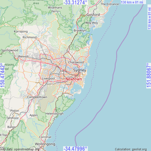
Newtown GPS coordinates[2]
33° 53' 54.06" South, 151° 10' 39.144" East
| Map corner | latitude | longitude |
|---|---|---|
| Upper-left | -33.31274°, | 150.47442° |
| Center: | -33.89835°, | 151.17754° |
| Lower-right: | -34.47996°, | 151.88067° |
| Map W x H: | 129.8×129.8 km | = 80.7×80.7mi |
| max Lat: | -10.58257° ⇑56% North |
| Newtown: | -33.89835° |
| min Lat: | ⇓44% South -43.31423° |
| min Long | Newtown | max Long |
| 113.53327° | 151.17754° | 153.61246° |
| W 72.5%⇐ | ⇒27.5% E |
Elevation
Elevation of Newtown is 37 m = 121 ft, and this is 85 m = 279 ft below average elevation for this country.
| Max E: |
1715 m = 5627 ft | 55.9% |
| Avg. | 122 m = 400 ft | |
| Newtown | 37 m = 121 ft | |
Min E: |
-2 m = -7 ft | 44.1% |
See also: Australia elevation on elevation.city.
Geographical zone
Newtown is located in South temperate zone (between Tropic of Capricorn and the Antarctic Circle). Distance of this Southern Tropic circle is 1163.2 km =722.8 mi to North.| Distance of | km | miles | from Newtown |
|---|---|---|---|
| Equator | 3769.1 | 2342 | to North |
| Tropic Capricorn | 1163.2 | 722.8 | to North |
| Antarctic Circle | 3632 | 2256.8 | to South |
| South Pole | 6237.9 | 3876.1 | to South |


Nearby cities:
15 places around Newtown: (largest is in red/bold)
• Alexandria
2 km =1.2 mi,  94°
94°
• Annandale
1.9 km =1.2 mi,  329°
329°
• Camperdown
1 km =0.6 mi,  353°
353°
• Chippendale
2.2 km =1.4 mi,  54°
54°
• Darlington
1.8 km =1.1 mi,  63°
63°
• Enmore
0.5 km =0.3 mi,  239°
239°
• Erskineville
0.9 km =0.6 mi,  121°
121°
• Eveleigh
1.4 km =0.9 mi,  77°
77°
• Forest Lodge
1.9 km =1.2 mi,  6°
6°
• Glebe
2.3 km =1.4 mi,  15°
15°
• Marrickville
2.3 km =1.4 mi, 243°
• Petersham
2.1 km =1.3 mi,  281°
281°
• Saint Peters
2.1 km =1.3 mi,  165°
165°
• Stanmore
1.3 km =0.8 mi,  291°
291°
• Sydenham
2.2 km =1.4 mi,  203°
203°
Sources, notices
• [Note1] Compared only with cities in Australia existing in our database
• [Src1] Map data: © OpenStreetMap contributors (CC-BY-SA)
• [Src2] Other city data from geonames.org with taken over terms of usage.
• [Src3] Geographical zone / Annual Mean Temperature by Robert A. Rohde @ Wikipedia
