Darlington geodata
Darlington (New South Wales) is a section of populated place; located in Australia in Australia/Sydney (GMT+10) time zone. With population of 3,067 people, there are 2217 cities with bigger population in this country. Compared to other cities in Australia, 55.6% of cities are located further ↑North; 72.9% of cities are located further ←West and 63.7% of cities have higher elevation than Darlington. Note1


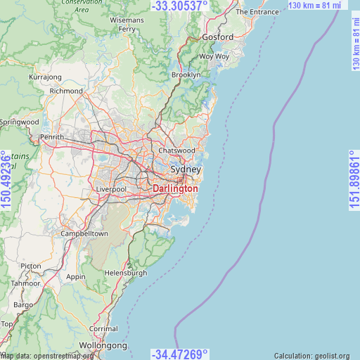
Darlington GPS coordinates[2]
33° 53' 27.708" South, 151° 11' 43.728" East
| Map corner | latitude | longitude |
|---|---|---|
| Upper-left | -33.30537°, | 150.49236° |
| Center: | -33.89103°, | 151.19548° |
| Lower-right: | -34.47269°, | 151.89861° |
| Map W x H: | 129.8×129.8 km | = 80.7×80.7mi |
| max Lat: | -10.58257° ⇑55.6% North |
| Darlington: | -33.89103° |
| min Lat: | ⇓44.4% South -43.31423° |
| min Long | Darlington | max Long |
| 113.53327° | 151.19548° | 153.61246° |
| W 72.9%⇐ | ⇒27.1% E |
Elevation
Elevation of Darlington is 28 m = 92 ft, and this is 94 m = 308 ft below average elevation for this country.
| Max E: |
1715 m = 5627 ft | 63.7% |
| Avg. | 122 m = 400 ft | |
| Darlington | 28 m = 92 ft | |
Min E: |
-2 m = -7 ft | 36.3% |
See also: Australia elevation on elevation.city.
Geographical zone
Darlington is located in South temperate zone (between Tropic of Capricorn and the Antarctic Circle). Distance of this Southern Tropic circle is 1162.4 km =722.3 mi to North.| Distance of | km | miles | from Darlington |
|---|---|---|---|
| Equator | 3768.3 | 2341.5 | to North |
| Tropic Capricorn | 1162.4 | 722.3 | to North |
| Antarctic Circle | 3632.8 | 2257.3 | to South |
| South Pole | 6238.7 | 3876.5 | to South |


Nearby cities:
15 places around Darlington: (largest is in red/bold)
• Alexandria
1.1 km =0.7 mi,  159°
159°
• Beaconsfield
2.3 km =1.4 mi,  168°
168°
• Camperdown
1.8 km =1.1 mi,  274°
274°
• Chippendale
0.5 km =0.3 mi,  20°
20°
• Enmore
2.3 km =1.4 mi,  242°
242°
• Erskineville
1.6 km =1 mi,  214°
214°
• Eveleigh
0.6 km =0.4 mi, 209°
• Forest Lodge
1.8 km =1.1 mi,  306°
306°
• Glebe
1.7 km =1.1 mi,  322°
322°
• Haymarket
1.6 km =1 mi,  33°
33°
• Newtown
1.8 km =1.1 mi, 243°
• Redfern
0.8 km =0.5 mi,  103°
103°
• Surry Hills
1.8 km =1.1 mi,  63°
63°
• Ultimo
1.5 km =0.9 mi,  5°
5°
• Zetland
2.2 km =1.4 mi,  146°
146°
Sources, notices
• [Note1] Compared only with cities in Australia existing in our database
• [Src1] Map data: © OpenStreetMap contributors (CC-BY-SA)
• [Src2] Other city data from geonames.org with taken over terms of usage.
• [Src3] Geographical zone / Annual Mean Temperature by Robert A. Rohde @ Wikipedia
