Annandale geodata
Annandale (New South Wales) is a section of populated place; located in Australia in Australia/Sydney (GMT+11) time zone. With population of 9,259 people, there are 671 cities with bigger population in this country. Compared to other cities in Australia, 55.2% of cities are located further ↑North; 72.3% of cities are located further ←West and 73.6% of cities have higher elevation than Annandale. Note1


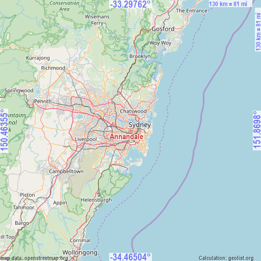
Annandale GPS coordinates[2]
33° 52' 59.988" South, 151° 10' 0.012" East
| Map corner | latitude | longitude |
|---|---|---|
| Upper-left | -33.29762°, | 150.46355° |
| Center: | -33.88333°, | 151.16667° |
| Lower-right: | -34.46504°, | 151.8698° |
| Map W x H: | 129.8×129.8 km | = 80.7×80.7mi |
| max Lat: | -10.58257° ⇑55.2% North |
| Annandale: | -33.88333° |
| min Lat: | ⇓44.8% South -43.31423° |
| min Long | Annandale | max Long |
| 113.53327° | 151.16667° | 153.61246° |
| W 72.3%⇐ | ⇒27.7% E |
Elevation
Elevation of Annandale is 20 m = 66 ft, and this is 102 m = 335 ft below average elevation for this country.
| Max E: |
1715 m = 5627 ft | 73.6% |
| Avg. | 122 m = 400 ft | |
| Annandale | 20 m = 66 ft | |
Min E: |
-2 m = -7 ft | 26.4% |
See also: Australia elevation on elevation.city.
Geographical zone
Annandale is located in South temperate zone (between Tropic of Capricorn and the Antarctic Circle). Distance of this Southern Tropic circle is 1161.6 km =721.8 mi to North.| Distance of | km | miles | from Annandale |
|---|---|---|---|
| Equator | 3767.5 | 2341 | to North |
| Tropic Capricorn | 1161.6 | 721.8 | to North |
| Antarctic Circle | 3633.7 | 2257.9 | to South |
| South Pole | 6239.6 | 3877.1 | to South |


Nearby cities:
15 places around Annandale: (largest is in red/bold)
• Camperdown
1.1 km =0.7 mi,  127°
127°
• Darlington
2.8 km =1.7 mi,  107°
107°
• Enmore
2 km =1.2 mi,  162°
162°
• Erskineville
2.8 km =1.7 mi,  140°
140°
• Eveleigh
2.7 km =1.7 mi,  119°
119°
• Forest Lodge
1.2 km =0.7 mi,  79°
79°
• Glebe
1.7 km =1.1 mi,  72°
72°
• Haberfield
2.1 km =1.3 mi,  271°
271°
• Leichhardt
1 km =0.6 mi, 269°
• Lewisham
2.3 km =1.4 mi,  226°
226°
• Lilyfield
0.9 km =0.6 mi,  352°
352°
• Newtown
1.9 km =1.2 mi,  149°
149°
• Petersham
1.7 km =1.1 mi,  220°
220°
• Rozelle
2.5 km =1.6 mi,  8°
8°
• Stanmore
1.2 km =0.7 mi,  190°
190°
Sources, notices
• [Note1] Compared only with cities in Australia existing in our database
• [Src1] Map data: © OpenStreetMap contributors (CC-BY-SA)
• [Src2] Other city data from geonames.org with taken over terms of usage.
• [Src3] Geographical zone / Annual Mean Temperature by Robert A. Rohde @ Wikipedia
