Newstead geodata
Newstead (Queensland) is a section of populated place; located in Australia in Australia/Brisbane (GMT+10) time zone. With population of 2,163 people, there are 2785 cities with bigger population in this country. Compared to other cities in Australia, 83% of cities are located further ↓South; 92.8% of cities are located further ←West and 93.8% of cities have higher elevation than Newstead. Note1


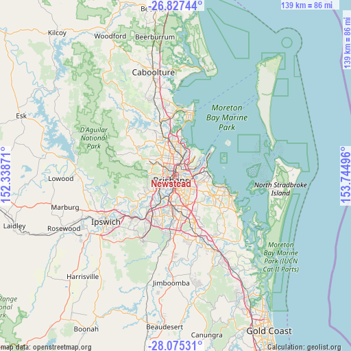
Newstead GPS coordinates[2]
27° 27' 11.304" South, 153° 2' 30.588" East
| Map corner | latitude | longitude |
|---|---|---|
| Upper-left | -26.82744°, | 152.33871° |
| Center: | -27.45314°, | 153.04183° |
| Lower-right: | -28.07531°, | 153.74496° |
| Map W x H: | 138.8×138.8 km | = 86.2×86.2mi |
| max Lat: | -10.58257° ⇑17% North |
| Newstead: | -27.45314° |
| min Lat: | ⇓83% South -43.31423° |
| min Long | Newstead | max Long |
| 113.53327° | 153.04183° | 153.61246° |
| W 92.8%⇐ | ⇒7.2% E |
Elevation
Elevation of Newstead is 7 m = 23 ft, and this is 115 m = 377 ft below average elevation for this country.
| Max E: |
1715 m = 5627 ft | 93.8% |
| Avg. | 122 m = 400 ft | |
| Newstead | 7 m = 23 ft | |
Min E: |
-2 m = -7 ft | 6.2% |
See also: Australia elevation on elevation.city.
Geographical zone
Newstead is located in South temperate zone (between Tropic of Capricorn and the Antarctic Circle). Distance of this Southern Tropic circle is 446.6 km =277.5 mi to North.| Distance of | km | miles | from Newstead |
|---|---|---|---|
| Equator | 3052.5 | 1896.7 | to North |
| Tropic Capricorn | 446.6 | 277.5 | to North |
| Antarctic Circle | 4348.7 | 2702.2 | to South |
| South Pole | 6954.6 | 4321.4 | to South |


Nearby cities:
15 places around Newstead: (largest is in red/bold)
• Ascot
2.9 km =1.8 mi,  33°
33°
• Balmoral
2.5 km =1.6 mi,  90°
90°
• Bowen Hills
1.1 km =0.7 mi,  336°
336°
• Brisbane
2.1 km =1.3 mi,  219°
219°
• Bulimba
1.6 km =1 mi,  77°
77°
• Fortitude Valley
1.1 km =0.7 mi,  246°
246°
• Hamilton
2.6 km =1.6 mi,  52°
52°
• Hawthorne
2.2 km =1.4 mi,  134°
134°
• Herston
2.5 km =1.6 mi,  292°
292°
• Kangaroo Point
2.7 km =1.7 mi,  190°
190°
• Kelvin Grove
2.9 km =1.8 mi,  281°
281°
• New Farm
1.7 km =1.1 mi,  158°
158°
• Spring Hill
2.1 km =1.3 mi,  243°
243°
• Teneriffe
0.6 km =0.4 mi,  120°
120°
• Windsor
2.3 km =1.4 mi,  325°
325°
Sources, notices
• [Note1] Compared only with cities in Australia existing in our database
• [Src1] Map data: © OpenStreetMap contributors (CC-BY-SA)
• [Src2] Other city data from geonames.org with taken over terms of usage.
• [Src3] Geographical zone / Annual Mean Temperature by Robert A. Rohde @ Wikipedia
