Bulimba geodata
Bulimba (Queensland) is a section of populated place; located in Australia in Australia/Brisbane (GMT+10) time zone. With population of 6,612 people, there are 1047 cities with bigger population in this country. Compared to other cities in Australia, 83% of cities are located further ↓South; 93.3% of cities are located further ←West and 77.5% of cities have higher elevation than Bulimba. Note1


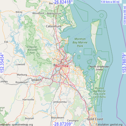
Bulimba GPS coordinates[2]
27° 26' 59.64" South, 153° 3' 27.576" East
| Map corner | latitude | longitude |
|---|---|---|
| Upper-left | -26.82418°, | 152.35454° |
| Center: | -27.4499°, | 153.05766° |
| Lower-right: | -28.07209°, | 153.76079° |
| Map W x H: | 138.8×138.8 km | = 86.2×86.2mi |
| max Lat: | -10.58257° ⇑17% North |
| Bulimba: | -27.4499° |
| min Lat: | ⇓83% South -43.31423° |
| min Long | Bulimba | max Long |
| 113.53327° | 153.05766° | 153.61246° |
| W 93.3%⇐ | ⇒6.7% E |
Elevation
Elevation of Bulimba is 17 m = 56 ft, and this is 105 m = 344 ft below average elevation for this country.
| Max E: |
1715 m = 5627 ft | 77.5% |
| Avg. | 122 m = 400 ft | |
| Bulimba | 17 m = 56 ft | |
Min E: |
-2 m = -7 ft | 22.5% |
See also: Australia elevation on elevation.city.
Geographical zone
Bulimba is located in South temperate zone (between Tropic of Capricorn and the Antarctic Circle). Distance of this Southern Tropic circle is 446.2 km =277.3 mi to North.| Distance of | km | miles | from Bulimba |
|---|---|---|---|
| Equator | 3052.1 | 1896.5 | to North |
| Tropic Capricorn | 446.2 | 277.3 | to North |
| Antarctic Circle | 4349 | 2702.3 | to South |
| South Pole | 6954.9 | 4321.6 | to South |


Nearby cities:
15 places around Bulimba: (largest is in red/bold)
• Ascot
2 km =1.2 mi,  0°
0°
• Balmoral
1 km =0.6 mi,  113°
113°
• Bowen Hills
2.1 km =1.3 mi,  288°
288°
• Brisbane
3.5 km =2.2 mi,  235°
235°
• Clayfield
3.4 km =2.1 mi, 0°
• Fortitude Valley
2.7 km =1.7 mi,  252°
252°
• Hamilton
1.3 km =0.8 mi,  22°
22°
• Hawthorne
1.9 km =1.2 mi,  179°
179°
• Morningside
2.2 km =1.4 mi,  127°
127°
• New Farm
2.2 km =1.4 mi,  204°
204°
• Newstead
1.6 km =1 mi,  257°
257°
• Norman Park
3.3 km =2.1 mi,  171°
171°
• Teneriffe
1.2 km =0.7 mi, 237°
• Windsor
3.2 km =2 mi,  297°
297°
• Wooloowin
3.4 km =2.1 mi,  333°
333°
Sources, notices
• [Note1] Compared only with cities in Australia existing in our database
• [Src1] Map data: © OpenStreetMap contributors (CC-BY-SA)
• [Src2] Other city data from geonames.org with taken over terms of usage.
• [Src3] Geographical zone / Annual Mean Temperature by Robert A. Rohde @ Wikipedia
