Teneriffe geodata
Teneriffe (Queensland) is a section of populated place; located in Australia in Australia/Brisbane (GMT+10) time zone. With population of 5,067 people, there are 1457 cities with bigger population in this country. Compared to other cities in Australia, 82.9% of cities are located further ↓South; 93% of cities are located further ←West and 73.6% of cities have higher elevation than Teneriffe. Note1


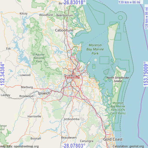
Teneriffe GPS coordinates[2]
27° 27' 21.132" South, 153° 2' 49.056" East
| Map corner | latitude | longitude |
|---|---|---|
| Upper-left | -26.83018°, | 152.34384° |
| Center: | -27.45587°, | 153.04696° |
| Lower-right: | -28.07803°, | 153.75009° |
| Map W x H: | 138.7×138.7 km | = 86.2×86.2mi |
| max Lat: | -10.58257° ⇑17.1% North |
| Teneriffe: | -27.45587° |
| min Lat: | ⇓82.9% South -43.31423° |
| min Long | Teneriffe | max Long |
| 113.53327° | 153.04696° | 153.61246° |
| W 93%⇐ | ⇒7% E |
Elevation
Elevation of Teneriffe is 20 m = 66 ft, and this is 102 m = 335 ft below average elevation for this country.
| Max E: |
1715 m = 5627 ft | 73.6% |
| Avg. | 122 m = 400 ft | |
| Teneriffe | 20 m = 66 ft | |
Min E: |
-2 m = -7 ft | 26.4% |
See also: Australia elevation on elevation.city.
Geographical zone
Teneriffe is located in South temperate zone (between Tropic of Capricorn and the Antarctic Circle). Distance of this Southern Tropic circle is 446.9 km =277.7 mi to North.| Distance of | km | miles | from Teneriffe |
|---|---|---|---|
| Equator | 3052.8 | 1896.9 | to North |
| Tropic Capricorn | 446.9 | 277.7 | to North |
| Antarctic Circle | 4348.4 | 2702 | to South |
| South Pole | 6954.3 | 4321.2 | to South |


Nearby cities:
15 places around Teneriffe: (largest is in red/bold)
• Ascot
2.9 km =1.8 mi,  21°
21°
• Balmoral
2 km =1.2 mi,  82°
82°
• Bowen Hills
1.7 km =1.1 mi,  324°
324°
• Brisbane
2.3 km =1.4 mi,  234°
234°
• Bulimba
1.2 km =0.7 mi,  57°
57°
• East Brisbane
2.8 km =1.7 mi,  185°
185°
• Fortitude Valley
1.5 km =0.9 mi,  264°
264°
• Hamilton
2.4 km =1.5 mi,  39°
39°
• Hawthorne
1.6 km =1 mi,  139°
139°
• Kangaroo Point
2.5 km =1.6 mi,  203°
203°
• Morningside
2.9 km =1.8 mi,  103°
103°
• New Farm
1.3 km =0.8 mi,  174°
174°
• Newstead
0.6 km =0.4 mi,  300°
300°
• Spring Hill
2.4 km =1.5 mi, 255°
• Windsor
2.8 km =1.7 mi, 320°
Sources, notices
• [Note1] Compared only with cities in Australia existing in our database
• [Src1] Map data: © OpenStreetMap contributors (CC-BY-SA)
• [Src2] Other city data from geonames.org with taken over terms of usage.
• [Src3] Geographical zone / Annual Mean Temperature by Robert A. Rohde @ Wikipedia
