Newcastle geodata
Newcastle (New South Wales) is a seat of a second-order administrative division; located in Australia in Australia/Sydney (GMT+11) time zone. With population of 308,308 people, there are 7 cities with bigger population in this country. Compared to other cities in Australia, 58.4% of cities are located further ↓South; 81.4% of cities are located further ←West and 99.9% of cities have higher elevation than Newcastle. Note1


Newcastle GPS coordinates[2]
32° 55' 46.308" South, 151° 46' 48.36" East
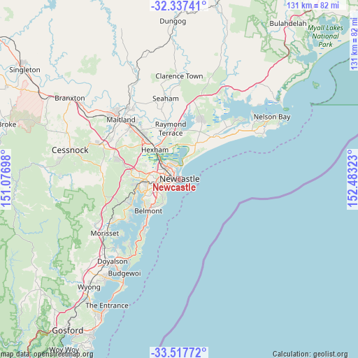
| Map corner | latitude | longitude |
|---|---|---|
| Upper-left | -32.33741°, | 151.07698° |
| Center: | -32.92953°, | 151.7801° |
| Lower-right: | -33.51772°, | 152.48323° |
| Map W x H: | 131.2×131.2 km | = 81.5×81.5mi |
| max Lat: | -10.58257° ⇑41.6% North |
| Newcastle: | -32.92953° |
| min Lat: | ⇓58.4% South -43.31423° |
| min Long | Newcastle | max Long |
| 113.53327° | 151.7801° | 153.61246° |
| W 81.4%⇐ | ⇒18.6% E |
Elevation
Elevation of Newcastle is 1 m = 3 ft, and this is 121 m = 397 ft below average elevation for this country.
| Max E: |
1715 m = 5627 ft | 99.9% |
| Avg. | 122 m = 400 ft | |
| Newcastle | 1 m = 3 ft | |
Min E: |
-2 m = -7 ft | 0.1% |
See also: Newcastle elevation on elevation.city.
Geographical zone
Newcastle is located in South temperate zone (between Tropic of Capricorn and the Antarctic Circle). Distance of this Southern Tropic circle is 1055.5 km =655.9 mi to North.| Distance of | km | miles | from Newcastle |
|---|---|---|---|
| Equator | 3661.4 | 2275.1 | to North |
| Tropic Capricorn | 1055.5 | 655.9 | to North |
| Antarctic Circle | 3739.8 | 2323.8 | to South |
| South Pole | 6345.6 | 3943 | to South |


Nearby cities:
15 places around Newcastle: (largest is in red/bold)
• Bar Beach
1.9 km =1.2 mi,  226°
226°
• Carrington
2.2 km =1.4 mi,  317°
317°
• Cooks Hill
0.9 km =0.6 mi,  248°
248°
• Hamilton
3.2 km =2 mi,  285°
285°
• Hamilton East
2.5 km =1.6 mi,  279°
279°
• Islington
3.5 km =2.2 mi,  299°
299°
• Maryville
3.1 km =1.9 mi,  311°
311°
• Newcastle East
0.8 km =0.5 mi,  75°
75°
• Newcastle West
2.2 km =1.4 mi, 284°
• Newcastle city centre
0.3 km =0.2 mi, 286°
• Stockton
2.3 km =1.4 mi,  8°
8°
• The Hill
0.2 km =0.1 mi, 227°
• The Junction
2.2 km =1.4 mi,  243°
243°
• Tighes Hill
3.7 km =2.3 mi, 312°
• Wickham
2.4 km =1.5 mi, 297°
Sources, notices
• [Note1] Compared only with cities in Australia existing in our database
• [Src1] Map data: © OpenStreetMap contributors (CC-BY-SA)
• [Src2] Other city data from geonames.org with taken over terms of usage.
• [Src3] Geographical zone / Annual Mean Temperature by Robert A. Rohde @ Wikipedia
