Narara geodata
Narara (New South Wales) is a section of populated place; located in Australia in Australia/Sydney (GMT+11) time zone. With population of 7,841 people, there are 855 cities with bigger population in this country. Compared to other cities in Australia, 54.6% of cities are located further ↓South; 76.2% of cities are located further ←West and 61.8% of cities have higher elevation than Narara. Note1


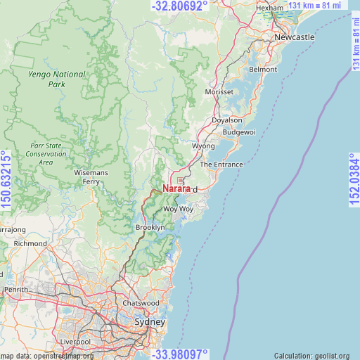
Narara GPS coordinates[2]
33° 23' 45.348" South, 151° 20' 6.972" East
| Map corner | latitude | longitude |
|---|---|---|
| Upper-left | -32.80692°, | 150.63215° |
| Center: | -33.39593°, | 151.33527° |
| Lower-right: | -33.98097°, | 152.0384° |
| Map W x H: | 130.5×130.5 km | = 81.1×81.1mi |
| max Lat: | -10.58257° ⇑45.4% North |
| Narara: | -33.39593° |
| min Lat: | ⇓54.6% South -43.31423° |
| min Long | Narara | max Long |
| 113.53327° | 151.33527° | 153.61246° |
| W 76.2%⇐ | ⇒23.8% E |
Elevation
Elevation of Narara is 30 m = 98 ft, and this is 92 m = 302 ft below average elevation for this country.
| Max E: |
1715 m = 5627 ft | 61.8% |
| Avg. | 122 m = 400 ft | |
| Narara | 30 m = 98 ft | |
Min E: |
-2 m = -7 ft | 38.2% |
See also: Australia elevation on elevation.city.
Geographical zone
Narara is located in South temperate zone (between Tropic of Capricorn and the Antarctic Circle). Distance of this Southern Tropic circle is 1107.4 km =688.1 mi to North.| Distance of | km | miles | from Narara |
|---|---|---|---|
| Equator | 3713.3 | 2307.3 | to North |
| Tropic Capricorn | 1107.4 | 688.1 | to North |
| Antarctic Circle | 3687.9 | 2291.6 | to South |
| South Pole | 6293.8 | 3910.8 | to South |


Nearby cities:
15 places around Narara: (largest is in red/bold)
• East Gosford
5 km =3.1 mi,  160°
160°
• Erina
6.5 km =4 mi,  128°
128°
• Gosford
3.3 km =2.1 mi,  165°
165°
• Holgate
7.6 km =4.7 mi,  93°
93°
• Kariong
6.2 km =3.9 mi,  217°
217°
• Lisarow
3.2 km =2 mi,  64°
64°
• Matcham
7.9 km =4.9 mi,  106°
106°
• Niagara Park
2.5 km =1.6 mi,  29°
29°
• North Gosford
2.5 km =1.6 mi,  142°
142°
• Point Clare
5.4 km =3.4 mi,  187°
187°
• Point Frederick
5 km =3.1 mi, 171°
• Somersby
5.8 km =3.6 mi,  304°
304°
• Tascott
6.4 km =4 mi,  198°
198°
• West Gosford
3.7 km =2.3 mi,  207°
207°
• Wyoming
2.7 km =1.7 mi, 109°
Sources, notices
• [Note1] Compared only with cities in Australia existing in our database
• [Src1] Map data: © OpenStreetMap contributors (CC-BY-SA)
• [Src2] Other city data from geonames.org with taken over terms of usage.
• [Src3] Geographical zone / Annual Mean Temperature by Robert A. Rohde @ Wikipedia
