Mount Dandenong geodata
Mount Dandenong (Victoria) is a section of populated place; located in Australia in Australia/Melbourne (GMT+11) time zone. With population of 1,214 people, there are 3562 cities with bigger population in this country. Compared to other cities in Australia, 88.8% of cities are located further ↑North; 60.7% of cities are located further →East and 92.9% of cities have lower elevation than Mount Dandenong. Note1


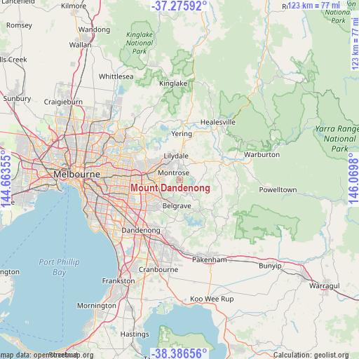
Mount Dandenong GPS coordinates[2]
37° 49' 59.988" South, 145° 22' 0.012" East
| Map corner | latitude | longitude |
|---|---|---|
| Upper-left | -37.27592°, | 144.66355° |
| Center: | -37.83333°, | 145.36667° |
| Lower-right: | -38.38656°, | 146.0698° |
| Map W x H: | 123.5×123.5 km | = 76.7×76.7mi |
| max Lat: | -10.58257° ⇑88.8% North |
| Mount Dandenong: | -37.83333° |
| min Lat: | ⇓11.2% South -43.31423° |
| min Long | Mount Dandenong | max Long |
| 113.53327° | 145.36667° | 153.61246° |
| W 39.3%⇐ | ⇒60.7% E |
Elevation
Elevation of Mount Dandenong is 469 m = 1539 ft, and this is 347 m = 1138 ft above average elevation for this country.
| Max E: |
1715 m = 5627 ft | 7.1% |
| Mount Dandenong | 469 m 1539 ft | |
| Avg. | 122 m = 400 ft | |
Min E: |
-2 m = -7 ft | 92.9% |
See also: Australia elevation on elevation.city.
Geographical zone
Mount Dandenong is located in South temperate zone (between Tropic of Capricorn and the Antarctic Circle). Distance of this Southern Tropic circle is 1600.8 km =994.7 mi to North.| Distance of | km | miles | from Mount Dandenong |
|---|---|---|---|
| Equator | 4206.7 | 2613.9 | to North |
| Tropic Capricorn | 1600.8 | 994.7 | to North |
| Antarctic Circle | 3194.5 | 1985 | to South |
| South Pole | 5800.4 | 3604.2 | to South |


Nearby cities:
15 places around Mount Dandenong: (largest is in red/bold)
• Bayswater North
6.1 km =3.8 mi,  277°
277°
• Ferny Creek
6.3 km =3.9 mi,  207°
207°
• Kallista
7.3 km =4.5 mi,  169°
169°
• Kalorama
1.9 km =1.2 mi,  0°
0°
• Kilsyth
5.7 km =3.5 mi,  310°
310°
• Kilsyth South
4.7 km =2.9 mi,  287°
287°
• Monbulk
6.9 km =4.3 mi,  131°
131°
• Montrose
2.4 km =1.5 mi,  321°
321°
• Mooroolbark
7.2 km =4.5 mi, 322°
• Mount Evelyn
5.7 km =3.5 mi,  14°
14°
• Olinda
1.9 km =1.2 mi,  180°
180°
• Sassafras
4 km =2.5 mi,  201°
201°
• Silvan
4.8 km =3 mi,  67°
67°
• The Basin
4.8 km =3 mi,  247°
247°
• The Patch
7.2 km =4.5 mi,  154°
154°
Sources, notices
• [Note1] Compared only with cities in Australia existing in our database
• [Src1] Map data: © OpenStreetMap contributors (CC-BY-SA)
• [Src2] Other city data from geonames.org with taken over terms of usage.
• [Src3] Geographical zone / Annual Mean Temperature by Robert A. Rohde @ Wikipedia
