Sassafras geodata
Sassafras (Victoria) is a section of populated place; located in Australia in Australia/Melbourne (GMT+11) time zone. With population of 1,010 people, there are 3806 cities with bigger population in this country. Compared to other cities in Australia, 89.7% of cities are located further ↑North; 60.9% of cities are located further →East and 94% of cities have lower elevation than Sassafras. Note1


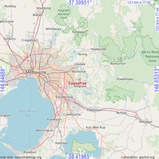
Sassafras GPS coordinates[2]
37° 52' 0.012" South, 145° 21' 0" East
| Map corner | latitude | longitude |
|---|---|---|
| Upper-left | -37.30951°, | 144.64688° |
| Center: | -37.86667°, | 145.35° |
| Lower-right: | -38.41965°, | 146.05313° |
| Map W x H: | 123.4×123.4 km | = 76.7×76.7mi |
| max Lat: | -10.58257° ⇑89.7% North |
| Sassafras: | -37.86667° |
| min Lat: | ⇓10.3% South -43.31423° |
| min Long | Sassafras | max Long |
| 113.53327° | 145.35° | 153.61246° |
| W 39.1%⇐ | ⇒60.9% E |
Elevation
Elevation of Sassafras is 542 m = 1778 ft, and this is 420 m = 1378 ft above average elevation for this country.
| Max E: |
1715 m = 5627 ft | 6% |
| Sassafras | 542 m 1778 ft | |
| Avg. | 122 m = 400 ft | |
Min E: |
-2 m = -7 ft | 94% |
See also: Australia elevation on elevation.city.
Geographical zone
Sassafras is located in South temperate zone (between Tropic of Capricorn and the Antarctic Circle). Distance of this Southern Tropic circle is 1604.5 km =997 mi to North.| Distance of | km | miles | from Sassafras |
|---|---|---|---|
| Equator | 4210.4 | 2616.2 | to North |
| Tropic Capricorn | 1604.5 | 997 | to North |
| Antarctic Circle | 3190.8 | 1982.7 | to South |
| South Pole | 5796.7 | 3601.9 | to South |


Nearby cities:
15 places around Sassafras: (largest is in red/bold)
• Belgrave
4.9 km =3 mi,  176°
176°
• Boronia
5.9 km =3.7 mi,  270°
270°
• Ferntree Gully
5.2 km =3.2 mi,  247°
247°
• Ferny Creek
2.4 km =1.5 mi,  218°
218°
• Kallista
4.5 km =2.8 mi,  141°
141°
• Kalorama
5.7 km =3.5 mi,  14°
14°
• Kilsyth South
6 km =3.7 mi,  329°
329°
• Montrose
5.6 km =3.5 mi,  0°
0°
• Mount Dandenong
4 km =2.5 mi,  21°
21°
• Olinda
2.4 km =1.5 mi,  38°
38°
• Selby
6.3 km =3.9 mi,  152°
152°
• Tecoma
4.1 km =2.5 mi,  186°
186°
• The Basin
3.5 km =2.2 mi,  302°
302°
• The Patch
5.4 km =3.4 mi,  121°
121°
• Upwey
4 km =2.5 mi,  201°
201°
Sources, notices
• [Note1] Compared only with cities in Australia existing in our database
• [Src1] Map data: © OpenStreetMap contributors (CC-BY-SA)
• [Src2] Other city data from geonames.org with taken over terms of usage.
• [Src3] Geographical zone / Annual Mean Temperature by Robert A. Rohde @ Wikipedia
