Kallista geodata
Kallista (Victoria) is a section of populated place; located in Australia in Australia/Melbourne (GMT+11) time zone. With population of 1,426 people, there are 3343 cities with bigger population in this country. Compared to other cities in Australia, 90.3% of cities are located further ↑North; 60.6% of cities are located further →East and 91.2% of cities have lower elevation than Kallista. Note1


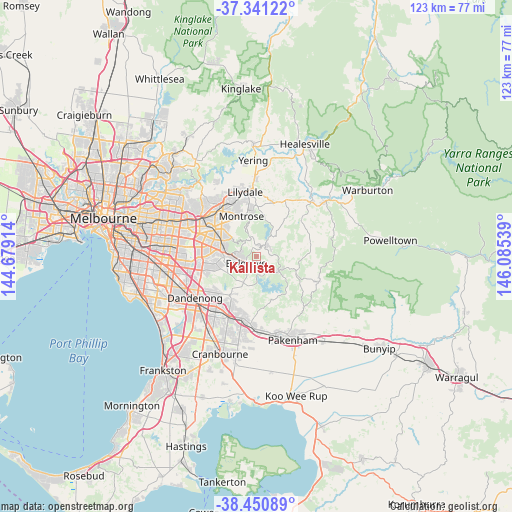
Kallista GPS coordinates[2]
37° 53' 53.34" South, 145° 22' 56.136" East
| Map corner | latitude | longitude |
|---|---|---|
| Upper-left | -37.34122°, | 144.67914° |
| Center: | -37.89815°, | 145.38226° |
| Lower-right: | -38.45089°, | 146.08539° |
| Map W x H: | 123.4×123.4 km | = 76.7×76.7mi |
| max Lat: | -10.58257° ⇑90.3% North |
| Kallista: | -37.89815° |
| min Lat: | ⇓9.7% South -43.31423° |
| min Long | Kallista | max Long |
| 113.53327° | 145.38226° | 153.61246° |
| W 39.4%⇐ | ⇒60.6% E |
Elevation
Elevation of Kallista is 418 m = 1371 ft, and this is 296 m = 971 ft above average elevation for this country.
| Max E: |
1715 m = 5627 ft | 8.8% |
| Kallista | 418 m 1371 ft | |
| Avg. | 122 m = 400 ft | |
Min E: |
-2 m = -7 ft | 91.2% |
See also: Australia elevation on elevation.city.
Geographical zone
Kallista is located in South temperate zone (between Tropic of Capricorn and the Antarctic Circle). Distance of this Southern Tropic circle is 1608 km =999.2 mi to North.| Distance of | km | miles | from Kallista |
|---|---|---|---|
| Equator | 4213.9 | 2618.4 | to North |
| Tropic Capricorn | 1608 | 999.2 | to North |
| Antarctic Circle | 3187.3 | 1980.5 | to South |
| South Pole | 5793.2 | 3599.7 | to South |


Nearby cities:
15 places around Kallista: (largest is in red/bold)
• Belgrave
2.9 km =1.8 mi,  240°
240°
• Belgrave Heights
4.6 km =2.9 mi,  227°
227°
• Belgrave South
5.8 km =3.6 mi, 227°
• Emerald
6.4 km =4 mi,  125°
125°
• Ferntree Gully
7.8 km =4.8 mi,  281°
281°
• Ferny Creek
4.6 km =2.9 mi,  290°
290°
• Menzies Creek
2.6 km =1.6 mi,  142°
142°
• Monbulk
4.7 km =2.9 mi,  55°
55°
• Mount Dandenong
7.3 km =4.5 mi,  349°
349°
• Olinda
5.5 km =3.4 mi, 345°
• Sassafras
4.5 km =2.8 mi,  321°
321°
• Selby
2.1 km =1.3 mi,  177°
177°
• Tecoma
3.3 km =2.1 mi,  260°
260°
• The Patch
1.9 km =1.2 mi,  68°
68°
• Upwey
4.3 km =2.7 mi,  267°
267°
Sources, notices
• [Note1] Compared only with cities in Australia existing in our database
• [Src1] Map data: © OpenStreetMap contributors (CC-BY-SA)
• [Src2] Other city data from geonames.org with taken over terms of usage.
• [Src3] Geographical zone / Annual Mean Temperature by Robert A. Rohde @ Wikipedia
