Mornington geodata
Mornington (Victoria) is a section of populated place; located in Australia in Australia/Melbourne (GMT+11) time zone. With population of 23,245 people, there are 118 cities with bigger population in this country. Compared to other cities in Australia, 94.3% of cities are located further ↑North; 65.5% of cities are located further →East and 67.2% of cities have higher elevation than Mornington. Note1


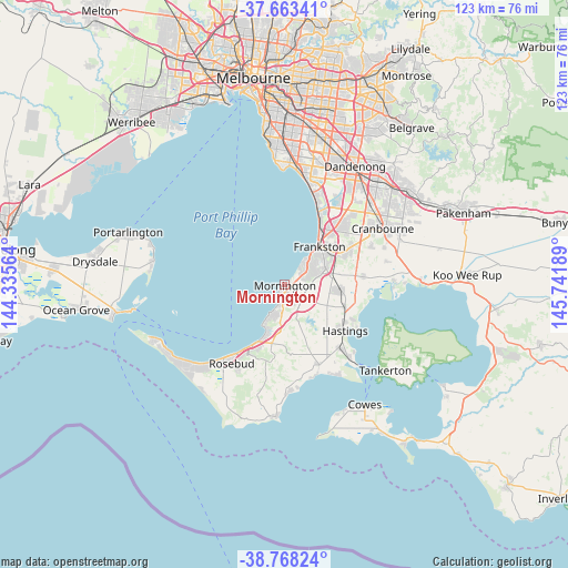
Mornington GPS coordinates[2]
38° 13' 4.512" South, 145° 2' 19.536" East
| Map corner | latitude | longitude |
|---|---|---|
| Upper-left | -37.66341°, | 144.33564° |
| Center: | -38.21792°, | 145.03876° |
| Lower-right: | -38.76824°, | 145.74189° |
| Map W x H: | 122.8×122.8 km | = 76.3×76.3mi |
| max Lat: | -10.58257° ⇑94.3% North |
| Mornington: | -38.21792° |
| min Lat: | ⇓5.7% South -43.31423° |
| min Long | Mornington | max Long |
| 113.53327° | 145.03876° | 153.61246° |
| W 34.5%⇐ | ⇒65.5% E |
Elevation
Elevation of Mornington is 25 m = 82 ft, and this is 97 m = 318 ft below average elevation for this country.
| Max E: |
1715 m = 5627 ft | 67.2% |
| Avg. | 122 m = 400 ft | |
| Mornington | 25 m = 82 ft | |
Min E: |
-2 m = -7 ft | 32.8% |
See also: Australia elevation on elevation.city.
Geographical zone
Mornington is located in South temperate zone (between Tropic of Capricorn and the Antarctic Circle). Distance of this Southern Tropic circle is 1643.5 km =1021.2 mi to North.| Distance of | km | miles | from Mornington |
|---|---|---|---|
| Equator | 4249.4 | 2640.5 | to North |
| Tropic Capricorn | 1643.5 | 1021.2 | to North |
| Antarctic Circle | 3151.7 | 1958.4 | to South |
| South Pole | 5757.6 | 3577.6 | to South |


Nearby cities:
15 places around Mornington: (largest is in red/bold)
• Baxter
9.9 km =6.2 mi,  78°
78°
• Dromana
14.4 km =8.9 mi,  206°
206°
• Frankston
11 km =6.8 mi,  42°
42°
• Frankston East
12.5 km =7.8 mi, 41°
• Frankston North
14.2 km =8.8 mi, 42°
• Frankston South
10.3 km =6.4 mi,  55°
55°
• Langwarrin
12.5 km =7.8 mi, 62°
• Langwarrin South
13.9 km =8.6 mi, 76°
• Moorooduc
6.8 km =4.2 mi,  88°
88°
• Mount Eliza
5.5 km =3.4 mi,  45°
45°
• Mount Martha
5.8 km =3.6 mi,  199°
199°
• Red Hill
14.8 km =9.2 mi,  187°
187°
• Safety Beach
11.3 km =7 mi, 197°
• Somerville
11.2 km =7 mi, 89°
• Tyabb
13.1 km =8.1 mi,  105°
105°
Sources, notices
• [Note1] Compared only with cities in Australia existing in our database
• [Src1] Map data: © OpenStreetMap contributors (CC-BY-SA)
• [Src2] Other city data from geonames.org with taken over terms of usage.
• [Src3] Geographical zone / Annual Mean Temperature by Robert A. Rohde @ Wikipedia
