Moorooduc geodata
Moorooduc (Victoria) is a section of populated place; located in Australia in Australia/Melbourne (GMT+11) time zone. With population of 1,063 people, there are 3738 cities with bigger population in this country. Compared to other cities in Australia, 94.3% of cities are located further ↑North; 64.2% of cities are located further →East and 58% of cities have lower elevation than Moorooduc. Note1


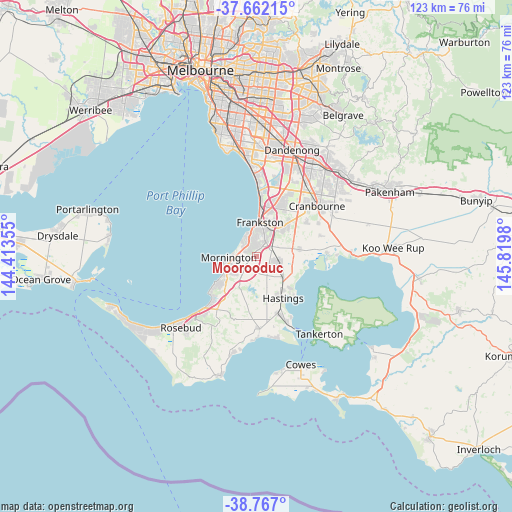
Moorooduc GPS coordinates[2]
38° 13' 0.012" South, 145° 7' 0.012" East
| Map corner | latitude | longitude |
|---|---|---|
| Upper-left | -37.66215°, | 144.41355° |
| Center: | -38.21667°, | 145.11667° |
| Lower-right: | -38.767°, | 145.8198° |
| Map W x H: | 122.8×122.8 km | = 76.3×76.3mi |
| max Lat: | -10.58257° ⇑94.3% North |
| Moorooduc: | -38.21667° |
| min Lat: | ⇓5.7% South -43.31423° |
| min Long | Moorooduc | max Long |
| 113.53327° | 145.11667° | 153.61246° |
| W 35.8%⇐ | ⇒64.2% E |
Elevation
Elevation of Moorooduc is 59 m = 194 ft, and this is 63 m = 207 ft below average elevation for this country.
| Max E: |
1715 m = 5627 ft | 42% |
| Avg. | 122 m = 400 ft | |
| Moorooduc | 59 m = 194 ft | |
Min E: |
-2 m = -7 ft | 58% |
See also: Australia elevation on elevation.city.
Geographical zone
Moorooduc is located in South temperate zone (between Tropic of Capricorn and the Antarctic Circle). Distance of this Southern Tropic circle is 1643.4 km =1021.2 mi to North.| Distance of | km | miles | from Moorooduc |
|---|---|---|---|
| Equator | 4249.3 | 2640.4 | to North |
| Tropic Capricorn | 1643.4 | 1021.2 | to North |
| Antarctic Circle | 3151.9 | 1958.5 | to South |
| South Pole | 5757.8 | 3577.7 | to South |


Nearby cities:
15 places around Moorooduc: (largest is in red/bold)
• Baxter
3.5 km =2.2 mi,  57°
57°
• Frankston
8 km =5 mi,  3°
3°
• Frankston East
9.4 km =5.8 mi,  8°
8°
• Frankston North
10.7 km =6.6 mi, 14°
• Frankston South
5.9 km =3.7 mi,  17°
17°
• Hastings
10.9 km =6.8 mi,  147°
147°
• Langwarrin
7.1 km =4.4 mi,  38°
38°
• Langwarrin South
7.4 km =4.6 mi,  65°
65°
• Mornington
6.8 km =4.2 mi,  268°
268°
• Mount Eliza
4.7 km =2.9 mi,  321°
321°
• Mount Martha
10.4 km =6.5 mi,  237°
237°
• Pearcedale
10.4 km =6.5 mi,  81°
81°
• Seaford
13.1 km =8.1 mi, 6°
• Somerville
4.4 km =2.7 mi,  90°
90°
• Tyabb
6.9 km =4.3 mi,  122°
122°
Sources, notices
• [Note1] Compared only with cities in Australia existing in our database
• [Src1] Map data: © OpenStreetMap contributors (CC-BY-SA)
• [Src2] Other city data from geonames.org with taken over terms of usage.
• [Src3] Geographical zone / Annual Mean Temperature by Robert A. Rohde @ Wikipedia
