Baxter geodata
Baxter (Victoria) is a section of populated place; located in Australia in Australia/Melbourne (GMT+11) time zone. With population of 2,113 people, there are 2816 cities with bigger population in this country. Compared to other cities in Australia, 94.1% of cities are located further ↑North; 63.4% of cities are located further →East and 54% of cities have lower elevation than Baxter. Note1


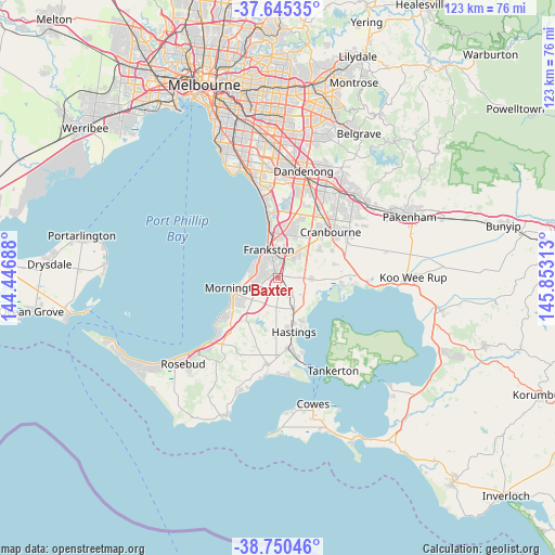
Baxter GPS coordinates[2]
38° 12' 0" South, 145° 9' 0" East
| Map corner | latitude | longitude |
|---|---|---|
| Upper-left | -37.64535°, | 144.44688° |
| Center: | -38.2°, | 145.15° |
| Lower-right: | -38.75046°, | 145.85313° |
| Map W x H: | 122.9×122.9 km | = 76.4×76.4mi |
| max Lat: | -10.58257° ⇑94.1% North |
| Baxter: | -38.2° |
| min Lat: | ⇓5.9% South -43.31423° |
| min Long | Baxter | max Long |
| 113.53327° | 145.15° | 153.61246° |
| W 36.6%⇐ | ⇒63.4% E |
Elevation
Elevation of Baxter is 51 m = 167 ft, and this is 71 m = 233 ft below average elevation for this country.
| Max E: |
1715 m = 5627 ft | 46% |
| Avg. | 122 m = 400 ft | |
| Baxter | 51 m = 167 ft | |
Min E: |
-2 m = -7 ft | 54% |
See also: Australia elevation on elevation.city.
Geographical zone
Baxter is located in South temperate zone (between Tropic of Capricorn and the Antarctic Circle). Distance of this Southern Tropic circle is 1641.5 km =1020 mi to North.| Distance of | km | miles | from Baxter |
|---|---|---|---|
| Equator | 4247.4 | 2639.2 | to North |
| Tropic Capricorn | 1641.5 | 1020 | to North |
| Antarctic Circle | 3153.7 | 1959.6 | to South |
| South Pole | 5759.6 | 3578.8 | to South |


Nearby cities:
15 places around Baxter: (largest is in red/bold)
• Carrum Downs
11.3 km =7 mi,  9°
9°
• Cranbourne South
10.7 km =6.6 mi,  47°
47°
• Frankston
6.6 km =4.1 mi,  338°
338°
• Frankston East
7.6 km =4.7 mi,  348°
348°
• Frankston North
8.5 km =5.3 mi,  359°
359°
• Frankston South
4 km =2.5 mi, 342°
• Langwarrin
4 km =2.5 mi,  21°
21°
• Langwarrin South
4 km =2.5 mi,  72°
72°
• Moorooduc
3.5 km =2.2 mi,  237°
237°
• Mornington
9.9 km =6.2 mi,  258°
258°
• Mount Eliza
6.1 km =3.8 mi,  287°
287°
• Pearcedale
7.4 km =4.6 mi,  92°
92°
• Seaford
11.2 km =7 mi, 352°
• Somerville
2.4 km =1.5 mi,  141°
141°
• Tyabb
6.3 km =3.9 mi,  152°
152°
Sources, notices
• [Note1] Compared only with cities in Australia existing in our database
• [Src1] Map data: © OpenStreetMap contributors (CC-BY-SA)
• [Src2] Other city data from geonames.org with taken over terms of usage.
• [Src3] Geographical zone / Annual Mean Temperature by Robert A. Rohde @ Wikipedia
