Minnamurra geodata
Minnamurra (New South Wales) is a section of populated place; located in Australia in Australia/Sydney (GMT+11) time zone. With population of 738 people, there are 4264 cities with bigger population in this country. Compared to other cities in Australia, 64.2% of cities are located further ↑North; 63.9% of cities are located further ←West and 69.8% of cities have higher elevation than Minnamurra. Note1


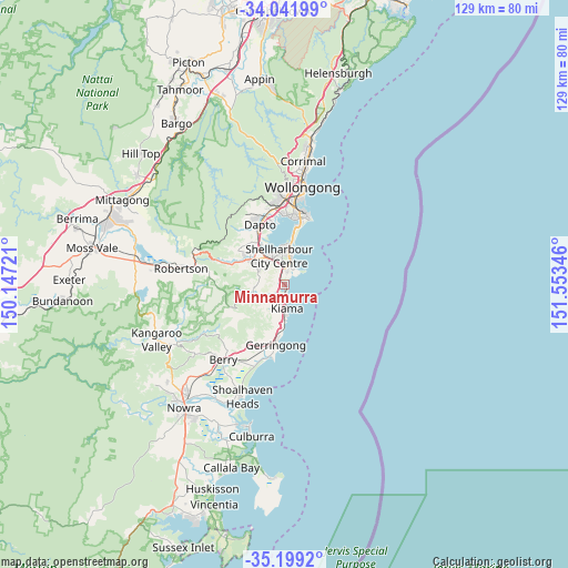
Minnamurra GPS coordinates[2]
34° 37' 21.396" South, 150° 51' 1.188" East
| Map corner | latitude | longitude |
|---|---|---|
| Upper-left | -34.04199°, | 150.14721° |
| Center: | -34.62261°, | 150.85033° |
| Lower-right: | -35.1992°, | 151.55346° |
| Map W x H: | 128.7×128.7 km | = 80×80mi |
| max Lat: | -10.58257° ⇑64.2% North |
| Minnamurra: | -34.62261° |
| min Lat: | ⇓35.8% South -43.31423° |
| min Long | Minnamurra | max Long |
| 113.53327° | 150.85033° | 153.61246° |
| W 63.9%⇐ | ⇒36.1% E |
Elevation
Elevation of Minnamurra is 23 m = 75 ft, and this is 99 m = 325 ft below average elevation for this country.
| Max E: |
1715 m = 5627 ft | 69.8% |
| Avg. | 122 m = 400 ft | |
| Minnamurra | 23 m = 75 ft | |
Min E: |
-2 m = -7 ft | 30.2% |
See also: Australia elevation on elevation.city.
Geographical zone
Minnamurra is located in South temperate zone (between Tropic of Capricorn and the Antarctic Circle). Distance of this Southern Tropic circle is 1243.8 km =772.9 mi to North.| Distance of | km | miles | from Minnamurra |
|---|---|---|---|
| Equator | 3849.7 | 2392.1 | to North |
| Tropic Capricorn | 1243.8 | 772.9 | to North |
| Antarctic Circle | 3551.5 | 2206.8 | to South |
| South Pole | 6157.4 | 3826 | to South |


Nearby cities:
15 places around Minnamurra: (largest is in red/bold)
• Albion Park
8.9 km =5.5 mi,  309°
309°
• Albion Park Rail
8.2 km =5.1 mi,  319°
319°
• Barrack Heights
6.5 km =4 mi,  5°
5°
• Barrack Point
6.9 km =4.3 mi,  15°
15°
• Blackbutt
5.8 km =3.6 mi,  348°
348°
• Flinders
4.4 km =2.7 mi, 5°
• Jamberoo
7.5 km =4.7 mi,  248°
248°
• Kiama
5.1 km =3.2 mi,  178°
178°
• Kiama Downs
1.3 km =0.8 mi,  162°
162°
• Lake Illawarra
8.5 km =5.3 mi,  3°
3°
• Mount Warrigal
8.4 km =5.2 mi, 351°
• Oak Flats
7.2 km =4.5 mi,  338°
338°
• Shell Cove
3.8 km =2.4 mi, 16°
• Shellharbour
4.6 km =2.9 mi, 18°
• Warilla
7.9 km =4.9 mi, 5°
Sources, notices
• [Note1] Compared only with cities in Australia existing in our database
• [Src1] Map data: © OpenStreetMap contributors (CC-BY-SA)
• [Src2] Other city data from geonames.org with taken over terms of usage.
• [Src3] Geographical zone / Annual Mean Temperature by Robert A. Rohde @ Wikipedia
