Shell Cove geodata
Shell Cove (New South Wales) is a populated place; located in Australia in Australia/Sydney (GMT+11) time zone. With population of 5,497 people, there are 1344 cities with bigger population in this country. Compared to other cities in Australia, 64% of cities are located further ↑North; 64.3% of cities are located further ←West and 80.4% of cities have higher elevation than Shell Cove. Note1


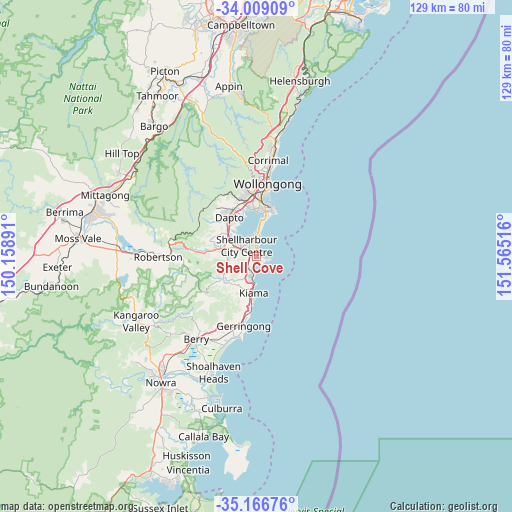
Shell Cove GPS coordinates[2]
34° 35' 23.784" South, 150° 51' 43.308" East
| Map corner | latitude | longitude |
|---|---|---|
| Upper-left | -34.00909°, | 150.15891° |
| Center: | -34.58994°, | 150.86203° |
| Lower-right: | -35.16676°, | 151.56516° |
| Map W x H: | 128.7×128.7 km | = 80×80mi |
| max Lat: | -10.58257° ⇑64% North |
| Shell Cove: | -34.58994° |
| min Lat: | ⇓36% South -43.31423° |
| min Long | Shell Cove | max Long |
| 113.53327° | 150.86203° | 153.61246° |
| W 64.3%⇐ | ⇒35.7% E |
Elevation
Elevation of Shell Cove is 15 m = 49 ft, and this is 107 m = 351 ft below average elevation for this country.
| Max E: |
1715 m = 5627 ft | 80.4% |
| Avg. | 122 m = 400 ft | |
| Shell Cove | 15 m = 49 ft | |
Min E: |
-2 m = -7 ft | 19.6% |
See also: Australia elevation on elevation.city.
Geographical zone
Shell Cove is located in South temperate zone (between Tropic of Capricorn and the Antarctic Circle). Distance of this Southern Tropic circle is 1240.1 km =770.6 mi to North.| Distance of | km | miles | from Shell Cove |
|---|---|---|---|
| Equator | 3846 | 2389.8 | to North |
| Tropic Capricorn | 1240.1 | 770.6 | to North |
| Antarctic Circle | 3555.1 | 2209 | to South |
| South Pole | 6161 | 3828.3 | to South |


Nearby cities:
15 places around Shell Cove: (largest is in red/bold)
• Albion Park
8.2 km =5.1 mi,  284°
284°
• Albion Park Rail
6.9 km =4.3 mi,  292°
292°
• Barrack Heights
2.9 km =1.8 mi,  350°
350°
• Barrack Point
3.2 km =2 mi,  15°
15°
• Blackbutt
3 km =1.9 mi,  312°
312°
• Flinders
1 km =0.6 mi,  319°
319°
• Kiama
8.8 km =5.5 mi,  185°
185°
• Kiama Downs
4.9 km =3 mi, 188°
• Lake Illawarra
4.8 km =3 mi, 353°
• Minnamurra
3.8 km =2.4 mi,  196°
196°
• Mount Warrigal
5.2 km =3.2 mi,  334°
334°
• Oak Flats
4.8 km =3 mi, 309°
• Shellharbour
0.8 km =0.5 mi,  30°
30°
• Warilla
4.2 km =2.6 mi,  355°
355°
• Windang
6.3 km =3.9 mi,  3°
3°
Sources, notices
• [Note1] Compared only with cities in Australia existing in our database
• [Src1] Map data: © OpenStreetMap contributors (CC-BY-SA)
• [Src2] Other city data from geonames.org with taken over terms of usage.
• [Src3] Geographical zone / Annual Mean Temperature by Robert A. Rohde @ Wikipedia
