Flinders geodata
Flinders (New South Wales) is a section of populated place; located in Australia in Australia/Sydney (GMT+11) time zone. With population of 6,558 people, there are 1059 cities with bigger population in this country. Compared to other cities in Australia, 63.9% of cities are located further ↑North; 64.1% of cities are located further ←West and 70.9% of cities have higher elevation than Flinders. Note1


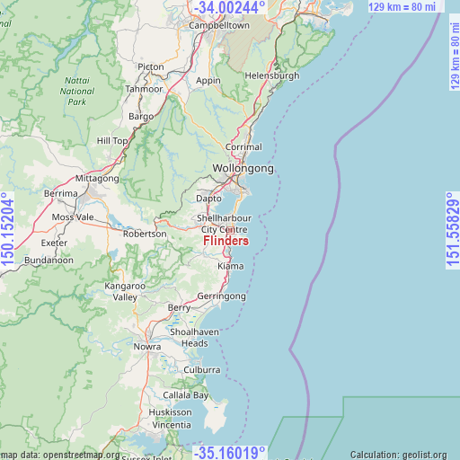
Flinders GPS coordinates[2]
34° 34' 59.988" South, 150° 51' 18.576" East
| Map corner | latitude | longitude |
|---|---|---|
| Upper-left | -34.00244°, | 150.15204° |
| Center: | -34.58333°, | 150.85516° |
| Lower-right: | -35.16019°, | 151.55829° |
| Map W x H: | 128.7×128.7 km | = 80×80mi |
| max Lat: | -10.58257° ⇑63.9% North |
| Flinders: | -34.58333° |
| min Lat: | ⇓36.1% South -43.31423° |
| min Long | Flinders | max Long |
| 113.53327° | 150.85516° | 153.61246° |
| W 64.1%⇐ | ⇒35.9% E |
Elevation
Elevation of Flinders is 22 m = 72 ft, and this is 100 m = 328 ft below average elevation for this country.
| Max E: |
1715 m = 5627 ft | 70.9% |
| Avg. | 122 m = 400 ft | |
| Flinders | 22 m = 72 ft | |
Min E: |
-2 m = -7 ft | 29.1% |
See also: Australia elevation on elevation.city.
Geographical zone
Flinders is located in South temperate zone (between Tropic of Capricorn and the Antarctic Circle). Distance of this Southern Tropic circle is 1239.4 km =770.1 mi to North.| Distance of | km | miles | from Flinders |
|---|---|---|---|
| Equator | 3845.3 | 2389.4 | to North |
| Tropic Capricorn | 1239.4 | 770.1 | to North |
| Antarctic Circle | 3555.9 | 2209.5 | to South |
| South Pole | 6161.8 | 3828.8 | to South |


Nearby cities:
15 places around Flinders: (largest is in red/bold)
• Albion Park
7.4 km =4.6 mi,  280°
280°
• Albion Park Rail
6.1 km =3.8 mi,  288°
288°
• Barrack Heights
2.1 km =1.3 mi,  4°
4°
• Barrack Point
2.7 km =1.7 mi,  32°
32°
• Blackbutt
2 km =1.2 mi,  309°
309°
• Haywards Bay
8 km =5 mi, 313°
• Kiama Downs
5.6 km =3.5 mi,  180°
180°
• Lake Illawarra
4.1 km =2.5 mi, 1°
• Minnamurra
4.4 km =2.7 mi,  185°
185°
• Mount Warrigal
4.2 km =2.6 mi,  337°
337°
• Oak Flats
3.8 km =2.4 mi, 307°
• Shell Cove
1 km =0.6 mi,  139°
139°
• Shellharbour
1.1 km =0.7 mi,  90°
90°
• Warilla
3.5 km =2.2 mi, 4°
• Windang
5.7 km =3.5 mi,  10°
10°
Sources, notices
• [Note1] Compared only with cities in Australia existing in our database
• [Src1] Map data: © OpenStreetMap contributors (CC-BY-SA)
• [Src2] Other city data from geonames.org with taken over terms of usage.
• [Src3] Geographical zone / Annual Mean Temperature by Robert A. Rohde @ Wikipedia
