Mascot geodata
Mascot (New South Wales) is a section of populated place; located in Australia in Australia/Sydney (GMT+11) time zone. With population of 15,985 people, there are 242 cities with bigger population in this country. Compared to other cities in Australia, 57% of cities are located further ↑North; 72.8% of cities are located further ←West and 86.8% of cities have higher elevation than Mascot. Note1


Mascot GPS coordinates[2]
33° 55' 33.528" South, 151° 11' 36.492" East
| Map corner | latitude | longitude |
|---|---|---|
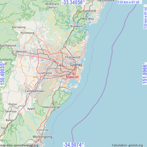
| Upper-left | -33.34056°, | 150.49035° |
| Center: | -33.92598°, | 151.19347° |
| Lower-right: | -34.5074°, | 151.8966° |
| Map W x H: | 129.7×129.7 km | = 80.6×80.6mi |
| max Lat: | -10.58257° ⇑57% North |
| Mascot: | -33.92598° |
| min Lat: | ⇓43% South -43.31423° |
| min Long | Mascot | max Long |
| 113.53327° | 151.19347° | 153.61246° |
| W 72.8%⇐ | ⇒27.2% E |
Elevation
Elevation of Mascot is 11 m = 36 ft, and this is 111 m = 364 ft below average elevation for this country.
| Max E: |
1715 m = 5627 ft | 86.8% |
| Avg. | 122 m = 400 ft | |
| Mascot | 11 m = 36 ft | |
Min E: |
-2 m = -7 ft | 13.2% |
See also: Australia elevation on elevation.city.
Geographical zone
Mascot is located in South temperate zone (between Tropic of Capricorn and the Antarctic Circle). Distance of this Southern Tropic circle is 1166.3 km =724.7 mi to North.| Distance of | km | miles | from Mascot |
|---|---|---|---|
| Equator | 3772.2 | 2343.9 | to North |
| Tropic Capricorn | 1166.3 | 724.7 | to North |
| Antarctic Circle | 3629 | 2255 | to South |
| South Pole | 6234.8 | 3874.1 | to South |


Nearby cities:
15 places around Mascot: (largest is in red/bold)
• Alexandria
3 km =1.9 mi,  10°
10°
• Beaconsfield
1.7 km =1.1 mi,  21°
21°
• Botany
2.2 km =1.4 mi,  174°
174°
• Daceyville
3 km =1.9 mi,  95°
95°
• Eastlakes
1.8 km =1.1 mi,  111°
111°
• Enmore
3.4 km =2.1 mi,  326°
326°
• Erskineville
2.7 km =1.7 mi,  344°
344°
• Kensington
2.7 km =1.7 mi,  76°
76°
• Kingsford
3.1 km =1.9 mi,  85°
85°
• Newtown
3.4 km =2.1 mi, 334°
• Pagewood
2.4 km =1.5 mi,  136°
136°
• Saint Peters
1.4 km =0.9 mi,  317°
317°
• Sydenham
2.6 km =1.6 mi,  293°
293°
• Tempe
3.1 km =1.9 mi,  275°
275°
• Zetland
2.5 km =1.6 mi,  34°
34°
Sources, notices
• [Note1] Compared only with cities in Australia existing in our database
• [Src1] Map data: © OpenStreetMap contributors (CC-BY-SA)
• [Src2] Other city data from geonames.org with taken over terms of usage.
• [Src3] Geographical zone / Annual Mean Temperature by Robert A. Rohde @ Wikipedia
