Zetland geodata
Zetland (New South Wales) is a section of populated place; located in Australia in Australia/Sydney (GMT+11) time zone. With population of 10,269 people, there are 563 cities with bigger population in this country. Compared to other cities in Australia, 56.3% of cities are located further ↑North; 73.5% of cities are located further ←West and 69.8% of cities have higher elevation than Zetland. Note1


Zetland GPS coordinates[2]
33° 54' 26.928" South, 151° 12' 30.852" East
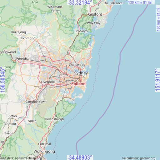
| Map corner | latitude | longitude |
|---|---|---|
| Upper-left | -33.32194°, | 150.50545° |
| Center: | -33.90748°, | 151.20857° |
| Lower-right: | -34.48903°, | 151.9117° |
| Map W x H: | 129.8×129.8 km | = 80.7×80.7mi |
| max Lat: | -10.58257° ⇑56.3% North |
| Zetland: | -33.90748° |
| min Lat: | ⇓43.7% South -43.31423° |
| min Long | Zetland | max Long |
| 113.53327° | 151.20857° | 153.61246° |
| W 73.5%⇐ | ⇒26.5% E |
Elevation
Elevation of Zetland is 23 m = 75 ft, and this is 99 m = 325 ft below average elevation for this country.
| Max E: |
1715 m = 5627 ft | 69.8% |
| Avg. | 122 m = 400 ft | |
| Zetland | 23 m = 75 ft | |
Min E: |
-2 m = -7 ft | 30.2% |
See also: Australia elevation on elevation.city.
Geographical zone
Zetland is located in South temperate zone (between Tropic of Capricorn and the Antarctic Circle). Distance of this Southern Tropic circle is 1164.2 km =723.4 mi to North.| Distance of | km | miles | from Zetland |
|---|---|---|---|
| Equator | 3770.2 | 2342.7 | to North |
| Tropic Capricorn | 1164.2 | 723.4 | to North |
| Antarctic Circle | 3631 | 2256.2 | to South |
| South Pole | 6236.9 | 3875.4 | to South |


Nearby cities:
15 places around Zetland: (largest is in red/bold)
• Alexandria
1.2 km =0.7 mi,  315°
315°
• Beaconsfield
0.9 km =0.6 mi,  239°
239°
• Centennial Park
2.5 km =1.6 mi,  65°
65°
• Chippendale
2.5 km =1.6 mi,  336°
336°
• Daceyville
2.9 km =1.8 mi,  146°
146°
• Darlington
2.2 km =1.4 mi,  326°
326°
• Eastlakes
2.7 km =1.7 mi,  173°
173°
• Erskineville
2.2 km =1.4 mi,  284°
284°
• Eveleigh
2 km =1.2 mi,  311°
311°
• Kensington
1.9 km =1.2 mi,  137°
137°
• Kingsford
2.5 km =1.6 mi, 136°
• Mascot
2.5 km =1.6 mi,  214°
214°
• Redfern
1.7 km =1.1 mi,  345°
345°
• Saint Peters
2.5 km =1.6 mi,  246°
246°
• Surry Hills
2.7 km =1.7 mi,  8°
8°
Sources, notices
• [Note1] Compared only with cities in Australia existing in our database
• [Src1] Map data: © OpenStreetMap contributors (CC-BY-SA)
• [Src2] Other city data from geonames.org with taken over terms of usage.
• [Src3] Geographical zone / Annual Mean Temperature by Robert A. Rohde @ Wikipedia
