Manilla geodata
Manilla (New South Wales) is a populated place; located in Australia in Australia/Sydney (GMT+11) time zone. With population of 2,516 people, there are 2558 cities with bigger population in this country. Compared to other cities in Australia, 71.2% of cities are located further ↓South; 61% of cities are located further ←West and 89.6% of cities have lower elevation than Manilla. Note1


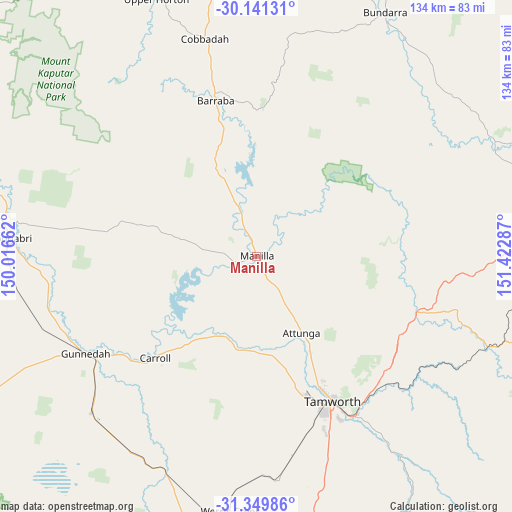
Manilla GPS coordinates[2]
30° 44' 50.928" South, 150° 43' 11.064" East
| Map corner | latitude | longitude |
|---|---|---|
| Upper-left | -30.14131°, | 150.01662° |
| Center: | -30.74748°, | 150.71974° |
| Lower-right: | -31.34986°, | 151.42287° |
| Map W x H: | 134.4×134.4 km | = 83.5×83.5mi |
| max Lat: | -10.58257° ⇑28.8% North |
| Manilla: | -30.74748° |
| min Lat: | ⇓71.2% South -43.31423° |
| min Long | Manilla | max Long |
| 113.53327° | 150.71974° | 153.61246° |
| W 61%⇐ | ⇒39% E |
Elevation
Elevation of Manilla is 358 m = 1175 ft, and this is 236 m = 774 ft above average elevation for this country.
| Max E: |
1715 m = 5627 ft | 10.4% |
| Manilla | 358 m 1175 ft | |
| Avg. | 122 m = 400 ft | |
Min E: |
-2 m = -7 ft | 89.6% |
See also: Australia elevation on elevation.city.
Geographical zone
Manilla is located in South temperate zone (between Tropic of Capricorn and the Antarctic Circle). Distance of this Southern Tropic circle is 812.9 km =505.1 mi to North.| Distance of | km | miles | from Manilla |
|---|---|---|---|
| Equator | 3418.8 | 2124.3 | to North |
| Tropic Capricorn | 812.9 | 505.1 | to North |
| Antarctic Circle | 3982.4 | 2474.5 | to South |
| South Pole | 6588.3 | 4093.8 | to South |


Nearby cities:
15 places around Manilla: (largest is in red/bold)
• Attunga
23.7 km =14.7 mi,  149°
149°
• Barraba
41.6 km =25.8 mi,  345°
345°
• Daruka
40.2 km =25 mi,  143°
143°
• East Tamworth
42.9 km =26.7 mi, 151°
• Hallsville
32.8 km =20.4 mi, 153°
• Hillvue
45.9 km =28.5 mi,  157°
157°
• Moonbi
45 km =28 mi,  131°
131°
• Moore
32.8 km =20.4 mi, 146°
• North Tamworth
41.6 km =25.8 mi, 152°
• Oxley Vale
39.1 km =24.3 mi, 153°
• Phillip
44.7 km =27.8 mi, 163°
• South Tamworth
44.7 km =27.8 mi, 154°
• Tamworth
43 km =26.7 mi, 152°
• West Tamworth
43.6 km =27.1 mi, 154°
• Westdale
40.3 km =25 mi, 161°
Sources, notices
• [Note1] Compared only with cities in Australia existing in our database
• [Src1] Map data: © OpenStreetMap contributors (CC-BY-SA)
• [Src2] Other city data from geonames.org with taken over terms of usage.
• [Src3] Geographical zone / Annual Mean Temperature by Robert A. Rohde @ Wikipedia
