Barraba geodata
Barraba (New South Wales) is a populated place; located in Australia in Australia/Sydney (GMT+11) time zone. With population of 1,362 people, there are 3401 cities with bigger population in this country. Compared to other cities in Australia, 71.7% of cities are located further ↓South; 59.7% of cities are located further ←West and 93.4% of cities have lower elevation than Barraba. Note1


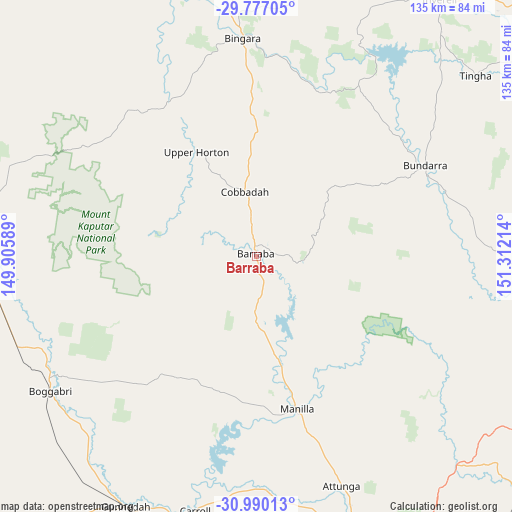
Barraba GPS coordinates[2]
30° 23' 7.692" South, 150° 36' 32.436" East
| Map corner | latitude | longitude |
|---|---|---|
| Upper-left | -29.77705°, | 149.90589° |
| Center: | -30.38547°, | 150.60901° |
| Lower-right: | -30.99013°, | 151.31214° |
| Map W x H: | 134.9×134.9 km | = 83.8×83.8mi |
| max Lat: | -10.58257° ⇑28.3% North |
| Barraba: | -30.38547° |
| min Lat: | ⇓71.7% South -43.31423° |
| min Long | Barraba | max Long |
| 113.53327° | 150.60901° | 153.61246° |
| W 59.7%⇐ | ⇒40.3% E |
Elevation
Elevation of Barraba is 493 m = 1617 ft, and this is 371 m = 1217 ft above average elevation for this country.
| Max E: |
1715 m = 5627 ft | 6.6% |
| Barraba | 493 m 1617 ft | |
| Avg. | 122 m = 400 ft | |
Min E: |
-2 m = -7 ft | 93.4% |
See also: Australia elevation on elevation.city.
Geographical zone
Barraba is located in South temperate zone (between Tropic of Capricorn and the Antarctic Circle). Distance of this Southern Tropic circle is 772.6 km =480.1 mi to North.| Distance of | km | miles | from Barraba |
|---|---|---|---|
| Equator | 3378.5 | 2099.3 | to North |
| Tropic Capricorn | 772.6 | 480.1 | to North |
| Antarctic Circle | 4022.6 | 2499.5 | to South |
| South Pole | 6628.5 | 4118.8 | to South |


Nearby cities:
15 places around Barraba: (largest is in red/bold)
• Attunga
64.7 km =40.2 mi,  159°
159°
• Bingara
57.5 km =35.7 mi,  356°
356°
• Blair Athol
49 km =30.4 mi,  233°
233°
• Boggabri
65.2 km =40.5 mi,  236°
236°
• Bundarra
50.7 km =31.5 mi,  62°
62°
• Daruka
80.3 km =49.9 mi,  154°
154°
• Gilgai
76.9 km =47.8 mi,  39°
39°
• Gunnedah
74.2 km =46.1 mi,  206°
206°
• Hallsville
74 km =46 mi, 159°
• Manilla
41.6 km =25.8 mi,  165°
165°
• Moore
73.4 km =45.6 mi, 156°
• Narrabri
79.6 km =49.5 mi,  274°
274°
• Oxley Vale
80.3 km =49.9 mi, 159°
• Tingha
75.1 km =46.7 mi,  50°
50°
• Westdale
81.9 km =50.9 mi, 163°
Sources, notices
• [Note1] Compared only with cities in Australia existing in our database
• [Src1] Map data: © OpenStreetMap contributors (CC-BY-SA)
• [Src2] Other city data from geonames.org with taken over terms of usage.
• [Src3] Geographical zone / Annual Mean Temperature by Robert A. Rohde @ Wikipedia
