Liverpool geodata
Liverpool (New South Wales) is a seat of a second-order administrative division; located in Australia in Australia/Sydney (GMT+10) time zone. With population of 27,545 people, there are 81 cities with bigger population in this country. Compared to other cities in Australia, 56.8% of cities are located further ↑North; 66.2% of cities are located further ←West and 86.8% of cities have higher elevation than Liverpool. Note1


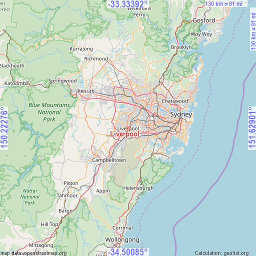
Liverpool GPS coordinates[2]
33° 55' 9.768" South, 150° 55' 33.168" East
| Map corner | latitude | longitude |
|---|---|---|
| Upper-left | -33.33392°, | 150.22276° |
| Center: | -33.91938°, | 150.92588° |
| Lower-right: | -34.50085°, | 151.62901° |
| Map W x H: | 129.8×129.8 km | = 80.7×80.7mi |
| max Lat: | -10.58257° ⇑56.8% North |
| Liverpool: | -33.91938° |
| min Lat: | ⇓43.2% South -43.31423° |
| min Long | Liverpool | max Long |
| 113.53327° | 150.92588° | 153.61246° |
| W 66.2%⇐ | ⇒33.8% E |
Elevation
Elevation of Liverpool is 11 m = 36 ft, and this is 111 m = 364 ft below average elevation for this country.
| Max E: |
1715 m = 5627 ft | 86.8% |
| Avg. | 122 m = 400 ft | |
| Liverpool | 11 m = 36 ft | |
Min E: |
-2 m = -7 ft | 13.2% |
See also: Australia elevation on elevation.city.
Geographical zone
Liverpool is located in South temperate zone (between Tropic of Capricorn and the Antarctic Circle). Distance of this Southern Tropic circle is 1165.6 km =724.3 mi to North.| Distance of | km | miles | from Liverpool |
|---|---|---|---|
| Equator | 3771.5 | 2343.5 | to North |
| Tropic Capricorn | 1165.6 | 724.3 | to North |
| Antarctic Circle | 3629.7 | 2255.4 | to South |
| South Pole | 6235.6 | 3874.6 | to South |


Nearby cities:
15 places around Liverpool: (largest is in red/bold)
• Ashcroft
2.4 km =1.5 mi,  278°
278°
• Cabramatta
2.6 km =1.6 mi,  17°
17°
• Cabramatta West
3.2 km =2 mi,  336°
336°
• Canley Heights
4.1 km =2.5 mi,  357°
357°
• Cartwright
3.4 km =2.1 mi,  259°
259°
• Chipping Norton
3.1 km =1.9 mi,  87°
87°
• Hammondville
4 km =2.5 mi,  143°
143°
• Heckenberg
3.5 km =2.2 mi,  290°
290°
• Lansvale
3.1 km =1.9 mi,  47°
47°
• Lurnea
3.2 km =2 mi,  236°
236°
• Miller
3.8 km =2.4 mi,  267°
267°
• Moorebank
3.9 km =2.4 mi,  133°
133°
• Mount Pritchard
2.7 km =1.7 mi,  313°
313°
• Sadleir
3.2 km =2 mi, 274°
• Warwick Farm
1.3 km =0.8 mi, 54°
Sources, notices
• [Note1] Compared only with cities in Australia existing in our database
• [Src1] Map data: © OpenStreetMap contributors (CC-BY-SA)
• [Src2] Other city data from geonames.org with taken over terms of usage.
• [Src3] Geographical zone / Annual Mean Temperature by Robert A. Rohde @ Wikipedia
