Moorebank geodata
Moorebank (New South Wales) is a section of populated place; located in Australia in Australia/Sydney (GMT+10) time zone. With population of 9,621 people, there are 635 cities with bigger population in this country. Compared to other cities in Australia, 57.6% of cities are located further ↑North; 66.8% of cities are located further ←West and 83.5% of cities have higher elevation than Moorebank. Note1


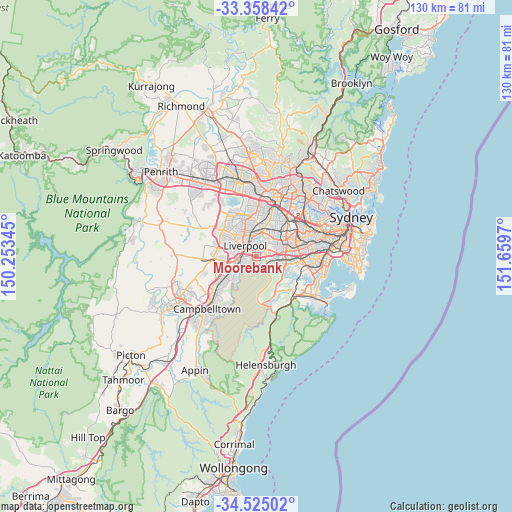
Moorebank GPS coordinates[2]
33° 56' 37.392" South, 150° 57' 23.652" East
| Map corner | latitude | longitude |
|---|---|---|
| Upper-left | -33.35842°, | 150.25345° |
| Center: | -33.94372°, | 150.95657° |
| Lower-right: | -34.52502°, | 151.6597° |
| Map W x H: | 129.7×129.7 km | = 80.6×80.6mi |
| max Lat: | -10.58257° ⇑57.6% North |
| Moorebank: | -33.94372° |
| min Lat: | ⇓42.4% South -43.31423° |
| min Long | Moorebank | max Long |
| 113.53327° | 150.95657° | 153.61246° |
| W 66.8%⇐ | ⇒33.2% E |
Elevation
Elevation of Moorebank is 13 m = 43 ft, and this is 109 m = 358 ft below average elevation for this country.
| Max E: |
1715 m = 5627 ft | 83.5% |
| Avg. | 122 m = 400 ft | |
| Moorebank | 13 m = 43 ft | |
Min E: |
-2 m = -7 ft | 16.5% |
See also: Australia elevation on elevation.city.
Geographical zone
Moorebank is located in South temperate zone (between Tropic of Capricorn and the Antarctic Circle). Distance of this Southern Tropic circle is 1168.3 km =725.9 mi to North.| Distance of | km | miles | from Moorebank |
|---|---|---|---|
| Equator | 3774.2 | 2345.2 | to North |
| Tropic Capricorn | 1168.3 | 725.9 | to North |
| Antarctic Circle | 3627 | 2253.7 | to South |
| South Pole | 6232.9 | 3872.9 | to South |


Nearby cities:
15 places around Moorebank: (largest is in red/bold)
• Casula
5.3 km =3.3 mi,  259°
259°
• Chipping Norton
2.9 km =1.8 mi,  4°
4°
• Condell Park
5.4 km =3.4 mi,  67°
67°
• East Hills
3.5 km =2.2 mi,  123°
123°
• Georges Hall
4.9 km =3 mi,  37°
37°
• Hammondville
0.7 km =0.4 mi,  219°
219°
• Holsworthy
4.5 km =2.8 mi,  168°
168°
• Lansvale
4.8 km =3 mi,  353°
353°
• Liverpool
3.9 km =2.4 mi,  313°
313°
• Milperra
2.3 km =1.4 mi,  78°
78°
• Panania
3.9 km =2.4 mi,  106°
106°
• Pleasure Point
3.9 km =2.4 mi,  139°
139°
• Voyager Point
2.3 km =1.4 mi, 135°
• Warwick Farm
3.9 km =2.4 mi,  332°
332°
• Wattle Grove
1.6 km =1 mi, 223°
Sources, notices
• [Note1] Compared only with cities in Australia existing in our database
• [Src1] Map data: © OpenStreetMap contributors (CC-BY-SA)
• [Src2] Other city data from geonames.org with taken over terms of usage.
• [Src3] Geographical zone / Annual Mean Temperature by Robert A. Rohde @ Wikipedia
