Lewisham geodata
Lewisham (Tasmania) is a populated place; located in Australia in Australia/Hobart (GMT+11) time zone. With population of 667 people, there are 4388 cities with bigger population in this country. Compared to other cities in Australia, 98.8% of cities are located further ↑North; 50.3% of cities are located further ←West and 58.5% of cities have lower elevation than Lewisham. Note1


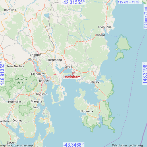
Lewisham GPS coordinates[2]
42° 49' 59.988" South, 147° 37' 0.012" East
| Map corner | latitude | longitude |
|---|---|---|
| Upper-left | -42.31555°, | 146.91355° |
| Center: | -42.83333°, | 147.61667° |
| Lower-right: | -43.3468°, | 148.3198° |
| Map W x H: | 114.7×114.7 km | = 71.3×71.3mi |
| max Lat: | -10.58257° ⇑98.8% North |
| Lewisham: | -42.83333° |
| min Lat: | ⇓1.2% South -43.31423° |
| min Long | Lewisham | max Long |
| 113.53327° | 147.61667° | 153.61246° |
| W 50.3%⇐ | ⇒49.7% E |
Elevation
Elevation of Lewisham is 60 m = 197 ft, and this is 62 m = 203 ft below average elevation for this country.
| Max E: |
1715 m = 5627 ft | 41.5% |
| Avg. | 122 m = 400 ft | |
| Lewisham | 60 m = 197 ft | |
Min E: |
-2 m = -7 ft | 58.5% |
See also: Australia elevation on elevation.city.
Geographical zone
Lewisham is located in South temperate zone (between Tropic of Capricorn and the Antarctic Circle). Distance of this Southern Tropic circle is 2156.7 km =1340.1 mi to North.| Distance of | km | miles | from Lewisham |
|---|---|---|---|
| Equator | 4762.6 | 2959.3 | to North |
| Tropic Capricorn | 2156.7 | 1340.1 | to North |
| Antarctic Circle | 2638.6 | 1639.5 | to South |
| South Pole | 5244.4 | 3258.7 | to South |


Nearby cities:
15 places around Lewisham: (largest is in red/bold)
• Acton Park
11.9 km =7.4 mi,  244°
244°
• Cambridge
13.6 km =8.5 mi,  270°
270°
• Carlton
4.5 km =2.8 mi,  135°
135°
• Clarendon Vale
15.4 km =9.6 mi,  245°
245°
• Cremorne
15.5 km =9.6 mi,  206°
206°
• Dodges Ferry
2.3 km =1.4 mi,  167°
167°
• Forcett
3.9 km =2.4 mi,  20°
20°
• Lauderdale
13.8 km =8.6 mi,  229°
229°
• Midway Point
8.3 km =5.2 mi,  300°
300°
• Oakdowns
15.1 km =9.4 mi, 239°
• Primrose Sands
7.3 km =4.5 mi, 143°
• Rokeby
15.5 km =9.6 mi, 241°
• Sandford
14.6 km =9.1 mi,  220°
220°
• Seven Mile Beach
9.5 km =5.9 mi, 252°
• Sorell
7.2 km =4.5 mi,  322°
322°
Sources, notices
• [Note1] Compared only with cities in Australia existing in our database
• [Src1] Map data: © OpenStreetMap contributors (CC-BY-SA)
• [Src2] Other city data from geonames.org with taken over terms of usage.
• [Src3] Geographical zone / Annual Mean Temperature by Robert A. Rohde @ Wikipedia
